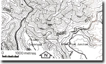
8424-5 Gibbo River - Mitta River Junction
|
This information has been developed from the publications:
|
Location: | 592662. 27 kilometres north-west of Benambra. | |
Abstract: | Exposures of Silurian Wombat Creek Group Sediments. | |
Access: | Fraser Tableland Track | |
Ownership: | Crown Land | |
Geology: | The Silurian Wombat Creek Group is well exposed in the stream channels and cliffs of the Mitta Mitta and Gibbo River. Near the junction of the two rivers, strongly jointed Toaks Creek Conglomerate is exposed. Bedding in the conglomerate is not evident, by occasional thin interbeds of sandstone indicate that the sequence is steeply dipping at this locality. The conglomerate is massive with clasts up to 35 centimetres in diameter. The clasts are predominantly quartzite and chert. Some derived from the Mitta Mitta Volcanics have been recorded. The Toaks Creek Conglomerate is overlain by the Quart Pot Limestone, which is exposed in bluffs on the Mitta Mitta River, just south of its junction with the Gibbo River. It is a bioclastic limestone and contains shelly fossils, which indicate a late Silurian River Siltstone which includes fossiliferous brown siltstone containing corals and brachiopods of late Silurian age. | |
Geomorphology: | The limestone at this locality contains several caves. Although the characteristics of these systems are not unknown in any detail. At least house bats know one of the caves. | |
Significance: | Regional. The area provides excellent exposures of the Wombat Creek Group sediments and may contain caves of importance. | |
Management: | It is unfortunate that many of the rock exposures and at least one of the caves will be flooded by the Dartmouth Dam impoundment. | |
References: | McAndrew, J. and Marsden, M.A.H. (eds)1973. Regional Guide to Victorian Geology. Second Edition, School of Geology, University of Melbourne. Bolger , P.F. 1979. 'Early Palaeozoic sedimentation and tectonics in north-east Victoria', Dept. Min. Energy Unpub. Rep. 1979/100 (open file) | |


