8424-2 Pheasant Creek
|
This information has been developed from the publications:
|
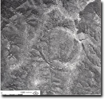
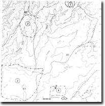
Location: | 805435. Eight kilometres south-west of Mount Gibbo. |  Pheasant Creek. Ring structure (eroded dyke). |
Abstract: | Ring shaped drainage pattern. | |
Access: | Tom Groggin Track. | |
Ownership: | Crown Land | |
Geology/Geomorphology: | A ring shaped drainage system occurs at the head of Pheasant Creek in a rock type designated on the 1:250,000 Geology Map Sheet as Ordovician sediments. However, this drainage pattern in uncharacteristic of Ordovician sediments and is suggestive of some form of structural or lithological control (eg. Small granite intrusion or a ring dyke.) | |
Significance: | Unknown. A detailed analysis of the lithology and structure of the area are necessary before a significance rating can be formulated. However, if the drainage pattern indicates the presence of a ring dyke, the significance rating would be high, as such features are rare in Eastern Victoria. | |
Management: | Investigation is needed to establish the significance and sensitivity of the site. Until the significance is known, no disturbance eg. Quarrying, logging, or land clearing should be permitted on or adjacent to the area of the site. | |


