8424-12 Limestone Road
|
This information has been developed from the publications:
|
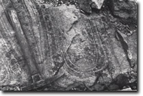
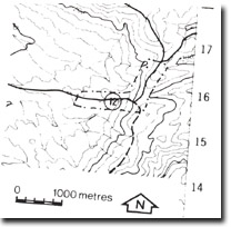
Location: | 878158. Near the junction of Limestone Road and Nunniong Roads, 24 kilometres east, north-east of Benambra. |  Limestone Road cutting. Unidentified structure, (deep weathering or flow banding), in highly altered gnessic granodiorite. |
Abstract: | Exposure of sheared gneissic granodiorite along Indi Fault. | |
Access: | Limestone Road | |
Ownership: | Crown Land | |
Geology: | A road cutting in Limestone Road provides almost a complete section across the Indi Fault. The fault zone extends for approximately 100 metres and is developed in gneissic granodiorite. The Marengo Granodiorite located to the west of the fault is highly weathered, medium grained, and shows no evidence of foliated or shearing. The gneissic granodiorite is crossed by numerous discrete shear zone in the area of the fault. These zones are characterised by slickensides and the obliteration of the original foliated texture of the gneissic granodiorite. The original texture is replaced by elongate quartz and feldspar laminae with a matrix of muscovite and chlorite. The altered rock resembles a tuffaceous or foliated acid volcanic rock. Shear planes in the fault zone dip to the north west at angles between 80 and 90 degrees and strike between N45E and N60E. This suggests that the fault is a high angle reverse fault. To the north of the Nunniong-Limestone road intersection, close to the fault line, several think dykes of basalt and a dyke of quartz porphyry occur, These are considered to be of Tertiary age. | |
Significance: | Regional. Sections which clearly display the structural and lithological variations associated with faulting are uncommon in East Gippsland. | |
Management: | The quality of the site would be enhanced by the maintenance of clear faces on the road cutting at this locality. | |
References: | Vandenberg, A.H.M. and O’Shea, P.J. 1980. 'Explanatory Notes on the Bairnsdale 1:250,00 geological map', Rep. geol. Surv. Vict., No.65. | |


