8424-11 Morass Creek Alluvial Plain
|
This information has been developed from the publications:
|
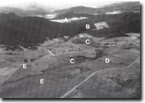
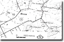
Location: | 670100. Four kilometres east of Benambra. |  Morass Creek, Benambra. Alluvial basin (A). Gorge (B). Drained Swampland (C). Alluvial fan (D). Terraces (E). |
Abstract: | Alluvial basin with swampland, terrace and an alluvial fan. | |
Access: | Mount Leicester Road. | |
Ownership: | Private Land. | |
Geology/Geomorphology: | At this locality Morass Creek occupies an extensive alluvial basin cut in Ordovician sediments and metamorphic rocks. It has been suggested that alluvial deposition resulted from the damming of Morass Creek by basalt flows to the north. In addition, it is likely that the stream gradient of Morass Creek was reduced by back tilting on Morass Creek Fault and other sub parallel faults, causing deposition of sediment in the area east of Benambra. The alluvial basin in characterised by extensive terrace and swamp development. Morass Creek originally flowed through the swampland without a clearly defined channel, but low level discharges are now confined to an artificially constructed drainage channel. Of additional interest, is the small alluvial fan projecting into the swampland at the moth of Sandy Creek. | |
Significance: | Regional. The area displays a series of fluvial landforms, which have originated through channel blockage and fault movements. Such a landform assemblage is of particular interest as it provides information on past climatic regimes and faulting history. | |
Management: | The site has been extensively modified by drainage of Morass Creek flat and it is recommended that no further drainage of the remaining wetlands be permitted. | |
References: | Crohn, P.W. 1950. 'The geology, petrology and physiography of the Omeo District, North-Eastern Victoria', Proc. R. Soc. Vict., 62 :1-70. | |


