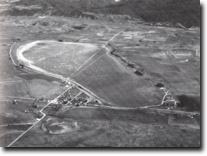
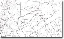
8424-10 Lake Omeo
|
This information has been developed from the publications:
|
Location: | 600090. One kilometre West of Benambra. |  Lake Omeo - Benambra |
Abstract: | Lake formed through the defeat of a stream by back tilting along the Morass Creek Fault. | |
Access: | Blowhard Road. | |
Ownership: | The Lake is Crown Land while all the surrounds are privately owned. | |
Geology: | Lake Omeo occupies a basin cut in Ordovician schists and granitic rocks, which outcrop in steep bluffs to the west and north of the Lake. The eastern side of the lake basin is bounded by a ridge of Ordovician sediments, a small horst block, which separates the lake from the Morass Creek alluvial flats. | |
Geomorpholgy: | Like Omeo originated through the damming of a small tributary of Morass Creek as a result of back tilting along the faults to the east of the lake. Another small tributary north of Lake Omeo, was diverted into the lake by fault movement. The lake basin is a broad flat plain which is only inundated during periods of high rainfall . It is bordered on the south-east by an arenate ridge of silts, clays and sands which separate the lake from swamp and alluvial terrace deposits to the east. The ridge has the form and composition of lunette. Small, well-developed lakeshore terraces occur around the lake and are prominent on the northern and eastern shores. Narrow gravel beaches composed of schist fragments and quartz occur at the base of the bluff on the western lake shoreline. | |
Significance: | State. Outstanding example of a lake basin developed by drainage disruption due to faulting. The crescentic ridge on the eastern side of the lake described as a lunette, is a unique landform in the highlands of eastern Victoria. The lake shore features display contrasting phases of lake evolution including periods of deep water (eg. Wave cut shoreline terrace) and more arid phases leading to lunette development. | |
Management: | The significance of the site requires the preservation of the lake shore features. | |
References: | Hills (1975) | |


