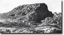
8324-2 Basalt Hill
8324-1 to 3 Bogong High Plains
Page top
This information has been developed from the publications:
|
Location: | 284174. The area includes Basalt Hill and Langfords Gap. |  Basalt Hill. Columnar jointing in Older Volcanics. |
Abstract: | Exposures of Bogong Volcanics, periglacial landforms. | |
Access: | Falls Creek- Omeo Road. | |
Ownership: | Crown Land. | |
Geology: | At Basalt Hill, columnar basalt, (Older Volcanics), overlies Kiewa Granodiorite. Abrupt changes in slope profiles on Basalt Hill indicate that at least three flows are present. The lowest consists of non-vesicular limburgites, while the upper flow is distinguishable by microphenocrysts of olivine. The upper basalt flow is exposed in small pinnacles on Basalt Hill, which display prominent columnar jointing. The lower flows are clearly exposed in an abandoned quarry on the northern side of Basalt Hill where columnar fan jointing is prominent, carbonates are commonly deposited along joint planes. | |
Geomorphology: | It has been suggested that Basalt Hill owe its shape to ice action, its western slope representing a scour or stoss slope with the eastern face representing the plucked or lee slope. This interpretation has been questioned and the shape of Basalt Hill has been attributed to varying erosion processes emphasising changes in lithology. The base of Basalt Hill is surrounding by a boulder field, which extends over Langfords Gap and into the head of Middle Creek. This boulder field has been interpreted either as a recessional or ground maraine, or of non-glacial origin, eg. a residual soil developed in situ in granodiorite. Periglacial features, both relict and active, are displayed on Basalt Hill. Mounds of columnar basalt rubble are common on the southern side of the Hill and these have formed through disintegration of the basalt columns by freeze-thaw weathering or frost wedging. Road cutting on the Omeo-Falls Creek Road at Basalt Hill, expose basalt boulders included in a soil profile developed on granite. The origin of this profile is probably related to past solifluction processes. | |
Significance: | Regional. The exposures of the Bogong Volcanics at Basalt Hill is the most accessible representative example of these rocks occurring in the High Plains area. The shape of Basalt Hill, in combination with the boulder fields of Langfords Gap, have been cited as evidence of glacial, although this interpretation has been questioned by later investigators the site remains of considerable significance in any future assessment of glaciation in the High Plains area. | |
Management: | The significance of the site is dependent upon the maintenance of the section in the Basalt Hill quarry, together with the small columnar basalt pinnacles on Basalt Hill and the Langfords Gap boulder deposit. Significance would be degraded if these features were obscured by construction work, or in the case of Langfords Gap, if removed or obscured by road making. | |
References: | Crohn, P.W. 1950. 'The geology, petrology and physiography of the Omeo District, North-Eastern Victoria', Proc. R. Soc. Vict., 62 :1-70. Beavis, F.C. 1962. 'The geology of the Kiewa area', Proc. R. Soc. Vict. 75 :349-510. | |


