8222-6 Macalister River Gorge - Burgoyne Gap
|
This information has been developed from the publications:
|
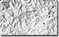
Location: | 670225 to 730235. 12 kilometres south of Licola. |  Entrenched meanders of the Macalister River Gorge. Outcrops of the Upper Devonian - Lower Carboniferous sediments (arrowed) |
Abstract: | Exposures of Ordovician Serpentine Creek Beds and Avon River Group volcanics and sediments. River gorge, cliffed escarpments, strike ridges. | |
Access: | Glenmaggie - Licola Road. | |
Ownership: | Predominantly Crown land with enclaves of private land along the Macalister River. | |
Geology/Geomorphology: | The Macalister River has cut a gorge through Ordovician Serpentine Creek Sandstone. Cliffed sections in the gorge provide exposures of this formation which is characterised by thick-bedded, poorly sorted, often coarse graded flysch sandstone with large muscovite flakes interbedded with green and grey siltstone. Avon River Group sediments and volcanics unconformably overlie the Ordovician sandstones to the west of Burgoyne Gap. These include the conglomerates and pebbly sandstone of the Moroka Glen Formation, the Wellington Rhyolite and the Mount Kent Conglomerate. These three formations are well exposed in road cuttings on the Glenmaggie - Licola Road between Burgoyne Gap and the Macalister River and are faulted against younger sediments (the Snowy Plains Formation) or the same Group to the west of Burgoyne Gap. In the headwaters of Hickey Creek, the whole group is folded into Licola Syncline. The eastern limb of the syncline brings the Mount Kent Conglomerate, the Wellington Rhyolite and the Moroka Glen Formation to the surface and these are characterised by cliffed escarpments and a prominent strike ridge oriented north-south forming McMillans Lookout Spur. | |
Significance: | Regional. The site provides easily accessible and representative exposures of the Ordovician Serpentine Creek Beds and the Avon River Group sediments and volcanics, together with the landforms characteristically associated with these formations. | |
Management: | Maintenance of clear faces on the Licola - Glenmaggie Road between Burgoyne Gap and the Macalister River would enhance the value of the site while dam construction and flooding of the Macalister River Gorge would obscure exposures and reduce the value of the site. | |
References: | Douglas, J.G. and Ferguson, J.A., (eds) 1976. Geology of Victoria. Geological Society of Australia, Special Publication No.5. | |


