
Reconnaissance survey of the ecology & land-use in the catchment of the Glenmaggie Reservoir
This report describes a broad-scale survey of the catchment of the Glenmaggie Reservoir. It contains brief descriptions of the climate, geology and physiography, and the soils and vegetation of the area. Areas having a regular pattern of land-forms are delineated. These areas are referred to as Land Systems. The environments of the land forms in each land system are described in terms of the above factors. Each land system is illustrated by a diagram which summarises the relationships between the factors of the environment. The forms of erosion found in the catchment are described, and the present land-use is discussed. A broad classification of land is made into land-use classes and recommendations for future land-use are made in the descriptions of the land systems. The report was authored by R K Rowe and R G Downes and was commissioned by the former Soil Conservation Authority in 1960.
 |
|
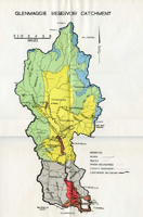 Glenmaggie Reservoir Catchment |
| |
© State of Victoria (Agriculture Victoria) 1996 - 2025.

This work, Victorian Resources Online, is licensed under a Creative Commons Attribution 4.0 licence. You are free to re-use the work under that licence, on the condition that you credit the State of Victoria (Agriculture Victoria) as author, indicate if changes were made and comply with the other licence terms.
The licence does not apply to ‘branding’ or some ‘images or photographs’ that may be owned by third parties. We ask you to seek prior approval to use images using the VRO feedback form. Access to higher quality images can also be provided on request.
This page was last updated on 23/03/2020.