
Yinnar (Yr)
 | Area: 113 sq. km (0.6%) This land system is confined to almost flat, alluvial terraces in the more humid parts of the Western lowlands. These terraces appear to be of similar age to those of Valencia land system but the materials are derived from Cretaceous sediments. There is some evidence of relict fluviatile land forms. The deposits are mainly silts and clays with minor admixtures of sand. The soils are diverse due mainly to variations in drainage which ranges from very poor to somewhat poor. This variation can be related to differences in local relief, to the permeability of layers within or below the soils and also to differences in seepage and run-off from adjacent higher land. Duplex soils tend to occupy the better-drained sites and gradational soils the more poorly-drained parts. In all soils the depth of periodic saturation by water appears to be reflected in the depth and degree of mottling. Erosion hazards are minor but because of periodic high water tables, soil structure can be readily impaired by trampling and trafficking. Some subsurface horizons are fluid when wet. The original vegetation, now almost entirely cleared, appears to have been mainly open forest II or III dominated by E. bridgesiana, E. ovata, E. radiata and E. viminalis. | 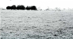 A broad alluvial plain backed by the Strzelecki Ranges (almost visible) which have provided much of the alluvium. |
| CLIMATE Rainfall, mean (mm) Temperature, mean (°C) Seasonal growth limitations |
Annual 700 - 1200; lowest January (40 - 70), highest October (70 - 100) Annual 12 - 14; lowest July (8 - 10), highest February (19 - 21) Temperature <10°C (av.): June - August Rainfall < potential evapotranspiration: November – March |
| GEOLOGY Age, lithology |
Lower Pleistocene alluvium of sands, silts and clays |
| PHYSIOGRAPHY Landscape Elevation range (m) Relative relief (m) Drainage pattern Drainage density (km/km2) |
Almost flat alluvial plains 20 - 100 0 - 5 Dendritic 0.9 |
| PRESENT LAND USE |
|
 |  |
| LAND COMPONENT Percentage of land system Diagnostic features | 1 50 Broad plains | 2 40 Slightly depressed parts of plains with poorer drainage than in component 1 | 3 5 Minor drainage depressions and adjacent steep slopes | 4 5 Narrow upstream terraces, no longer flood prone |
| PHYSIOGRAPHY Slope %, typical and (range) Slope shape | 1, (0 - 2) Straight | 1, (0 - 2) Slightly concave | Variable, (0 - 30) Concave | 1, (0 - 2) Straight |
| SOIL | ||||
| Parent material | Mainly fine-textured alluvial material, mostly derived from surrounding Cretaceous mudstone, shale and sandstone loam | |||
| Description | Dark greyish brown sandy loam to light clay topsoil with gradual or abrupt change to grey, light yellowish brown or pale brown clay subsoil. Profiles often moderately to slightly acid in the top, becoming neutral at depth. All soils with sign of poor drainage such as grey colours and mottling, with the extent of mottling being indicative of severity | |||
Duplex and gradational soils with upper topsoil often whole coloured | Mainly gradational soils with entire profile commonly mottled; high water tables are common throughout the year | Duplex soils with upper topsoil generally whole coloured | ||
| Classification | Yellow Podzolic Soils, Wiesenboden, Solodic Soils Dy3. - , Gn3. - , Gn4.5- | Wiesenboden; some Humic Gleys, Gleyed Podzolic Soils, Solodic Soils Gn3.72, Gn3.92, Gn3.93, Gn3.95, Gn4.51, Gn4.52, Uf6.61, Dy3.22 | Yellow Podzolic Soils; some, Gleyed Podzolic Soils, Solodic Soils Mostly Dy3.11, also Dy3.41, Dy3.42 | |
| Surface texture | Variable sandy loam to light clay | Variable; sandy loam to light clay | Sandy loam to loam; may be clay loam | |
| Surface consistence | Slightly hard to hard when dry | Slightly hard to hard when dry | Generally slightly hard when dry | |
| Depth (m) | >2.0 | >2.0 | >2.0 | |
| Nutrient status | Moderate | Moderate | Moderate | |
| Available soil water capacity | Moderate | Moderate | Moderate | |
| Perviousness to water | Slow | Slow | Slow | |
| Drainage | Poor to somewhat poor | Very poor to poor | Poor to somewhat poor | |
| Exposed stone (%) | 0 | 0 | 0 | |
| Sampled profile number | - | - | - | |
| NATIVE VEGETATION Structure of vegetation and characteristic species of dominant stratum (+ Predominant species) | Open forest II, III, sometimes shrubby or sedgey: Pure or mixed stands of E. ovata, E. viminalis, E. radiata and occasionally E. bridgesiana; in addition, E. obliqua grows in component 4 | |||
Disturbance | Affected process and trend | Primary resultant deterioration | Causal activities | Primary off-site process | ||
Form | Susceptibility of components | Incidence within components | ||||
| Alteration of vegetation: — reduction in leaf area, rooting depth and/or perenniality | Reduced transpiration, resulting in a raised watertable | Waterlogging | 1,4; low 2; moderate | Common; in low-lying areas | Reduced plant water-use in the catchment | Increased movement of water to groundwater and raised watertables |
| Increased exposure of surface soil | Increased overland flow and soil detachment | Sheet and rill erosion | 3; low - moderate | Uncommon | Clearing, burning, overgrazing, road and dam building and other earth-moving activities, trafficking by stock and vehicles. | Increased ponding and sedimentation in low-lying areas |
| Increased physical pressure on soil | Increased compaction With Reduced infiltration | Structure decline Sheet and rill erosion | 1,4; low – moderate 2,3; moderate 3; low - moderate | Uncommon Uncommon | Increased trafficking, cultivation, overgrazing, export of organic matter As for sheet and rill erosion above | - Increased ponding of water in low-lying areas |
| Increased soil disruption | Increased soil break-up | Gully erosion | 3 ; low - moderate | Uncommon | As for sheet and rill erosion above | Increased sediment load and turbidity of streams. |
| Comments: - | ||||||
© State of Victoria (Agriculture Victoria) 1996 - 2025.

This work, Victorian Resources Online, is licensed under a Creative Commons Attribution 4.0 licence. You are free to re-use the work under that licence, on the condition that you credit the State of Victoria (Agriculture Victoria) as author, indicate if changes were made and comply with the other licence terms.
The licence does not apply to ‘branding’ or some ‘images or photographs’ that may be owned by third parties. We ask you to seek prior approval to use images using the VRO feedback form. Access to higher quality images can also be provided on request.
This page was last updated on 23/03/2020.