Westbury 2 (W2)
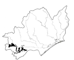
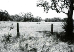
 | Area: 361 sq. km (1.8%) Westbury 2 is similar to Westbury 1, consisting of gently undulating plains and low hills on the earlier Pleistocene terrace and the more distal parts of the Tertiary flood plains deposits. Dissection is well established with most of the original land surface having been removed. However, quite large remnants of the original surface occur near Westbury. Westbury 2 differs from Westbury 1 in that it occurs in the humid Western lowlands and hence has a more humid climate with associated vegetation differences. Soils are very similar to those in Westbury 1 and are deep, leached, very acidic and of low fertility. Yellowish brown duplex soils predominate but there is some variation in topsoil texture and consistency, degree of subsurface mottling and the reaction of the lower subsoil, which ranges from strongly acidic to neutral. The subsurface soil tends to become fluid when wet. The subsoils with neutral reaction are probably highly dispersive and susceptible to gully erosion. The vegetation was probably mainly an open forest II, often shrubby prior to clearing. Only small areas of native vegetation now remain. |  Gentle slopes, typical of Westbury 2 land system, south of Traralgon |
| GEOLOGY Age, lithology | Distal parts of Tertiary floodplain deposits and Lower Pleistocene terrace deposits; gravels, sands, silts and clays |
| PHYSIOGRAPHY Landscape Elevation range (m) Relative relief (m) Drainage pattern Drainage density (km/km2) | Sloping to gently undulating plains and low hills 20 - 200 10 - 120 Dendritic 1.0 |
| PRESENT LAND USE | Mostly cleared: grazing of beef and dairy cattle and, to a lesser extent sheep on improved pastures; softwood plantations (limited) Minor proportion uncleared: bush grazing of cattle (limited); apiculture |
 |  |
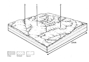
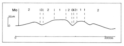
| LAND COMPONENT Percentage of land system Diagnostic features | 1 15 Almost flat plateaux remnants | 2 75 Gentle to moderate slopes, rarely steep | 3 10 Drainage depressions, in places permanently wet |
| PHYSIOGRAPHY Slope %, typical and (range) Slope shape | 2, (0 - 5) Straight | 4 - 8, (0 - 15) Variable | 2, (0 - 5) Concave |
| SOIL | |||
| Parent material | Mainly clay, silt and sand, with some intermixed quartz gravel | Locally derived alluvium | |
| Description | Very dark greyish brown sandy loam to sandy clay loam topsoil grading into greyish brown or yellowish brown sandy clay loam subsurface soil, sometimes mottled and fluid when wet. Yellowish brown or dark yellowish brown strongly mottled clay subsoil below. Subsoil usually moderately to strongly acidic, sometimes neutral at depth | Limited observations — probably variable; strongly mottled pale brown to grey medium to heavy textured soils observed | |
| Classification | Mostly Yellow Podzolic Soils and Soloths; some Solodic Soils; rarely Brown Podzolic Soils Dy3.41, Dy3.21, Dy3.42, Dy3.22; rarely Db2.41, Db2.42, Gn4.81 | Humic Gleys - | |
| Surface texture | Mostly sandy loam to sandy clay loam | Sand to sandy clay loam | |
| Surface consistence | Friable when moist | Friable when moist | |
| Depth (m) | >2.0 | >2.0 | |
| Nutrient status | Low | Low | |
| Available soil water capacity | Moderate | Variable | |
| Perviousness to water | Very slow to slow | Probably variable | |
| Drainage | Mostly somewhat poor | Very poor to poor | |
| Exposed stone (%) | Usually 0 | 0 | |
| Sampled profile number | 60 | 50 | - |
| NATIVE VEGETATION Structure of vegetation and characteristic species of dominant stratum (+ Predominant species) | Open forest II: Mainly mixed forests with variable composition, species including — E. dives, E. obliqua, E. radiata, E. bridgesiana (one or more of which predominant) E. cephalocarpa and, in some more poorly drained areas, E. ovata | Open forest II, III, often shrubby: Limited data — probably E. viminalis+ and/or E. ovata+; E. obliqua, E. radiata and E. bridgesiana commonly associated | |
Disturbance | Affected process and trend | Primary resultant deterioration | Causal activities | Primary off-site process | ||
Form | Susceptibility of components | Incidence within components | ||||
| Alteration of vegetation: — reduction in leaf area, rooting depth and/or perenniality | Reduced transpiration, resulting in increased deep percolation | Nutrient loss | Not determined | Not determined | Removal of trees | Increased movement of water to groundwater; increased base-flow of streams |
| Increased exposure of surface soil | Increased overland flow and soil detachment | Sheet and rill erosion | 1; low 2; moderate | Not determined | Clearing, overgrazing, road and dam building and other earth-moving activities, trafficking by stock and vehicles. | Increased flash flows and sediment load. |
| Increased physical pressure on soil | Increased compaction With Reduced infiltration | Structure decline Sheet and rill erosion | 1,2; low 1; low 2; moderate | Not determined Not determined | Increased trafficking, cultivation, overgrazing, export of organic matter As for sheet and rill erosion above | - Increased flash flows |
| Increased soil disruption | Increased soil break-up | Gully erosion | 1,2; low 3; moderate | Not determined | As for sheet and rill erosion above | Increased sediment load |
| Comments: No observations of deterioration | ||||||


