
Livingston (Ln)
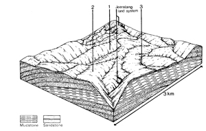
 | Area: 28 sq. km (0.2%) The Balook Block of the South Victorian Uplands was raised, almost without tilting, between fault and monocline systems to the north and south. Some areas near the crest of the uplifted block have escaped deep dissection and remain as plateaux. These occur along the southern edge of the survey area and are mapped as Livingston land system. The slopes of the plateaux are gentle but as dissection is intense with shallow incision, the local terrain consists of steep-sided, low hills. The bedrock is composed of Cretaceous mudstones, siltstones and sandstones as for the adjacent Gunyah and Jeeralang land systems. A humid climate acting on predominantly fine-textured sedimentary rock has produced deep, acidic, clayey soils. As with Gunyah and Jeeralang land systems these soils also tend to have higher nutrient status than most soils on sedimentary rock in the survey area. The native vegetation is mainly E. regnans layered open forest III. | 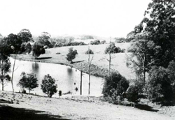 The low steep hills are produced by intense shallow dissection of the remnant plateau surface. The deeply dissected surrounding terrain is mapped in Gunyah and Jeeralang land systems. |
| CLIMATE Rainfall, mean (mm) Temperature, mean (°C) Seasonal growth limitations |
Annual 900 - 1600; lowest January (60 - 90), highest August or October (120 - 150) Annual 8 - 12; lowest July (3 - 7), highest February (16 - 20) Temperature <10°C (av.): May - September Rainfall < potential evapotranspiration: December - February; occasional winter snow |
| GEOLOGY Age, lithology |
Cretaceous mudstones, siltstones and sandstones of the Strzelecki Group |
| PHYSIOGRAPHY Landscape Elevation range (m) Relative relief (m) Drainage pattern Drainage density (km/km2) |
Low steep hills with approximately accordant crests produced by intense shallow dissection 360 - 580 40 - 140 Dendritic 1.9 |
| PRESENT LAND USE |
Minor proportion cleared: grazed mainly by beef and dairy cattle on improved pastures; softwood plantations |
 | 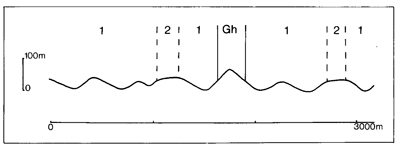 |
| LAND COMPONENT Percentage of land system Diagnostic features | 1 90 Short steep slopes | 2 10 Undissected plateau remnants with gentle slopes |
| PHYSIOGRAPHY Slope %, typical and (range) Slope shape | 35 - 45, (30 - 60) Straight | 10 - 15, (0 - 30) Convex |
| SOIL | ||
| Parent material | Mudstone, siltstone and sandstone | |
| Description | Very dark greyish brown or black clay loam grading into brown or yellowish brown blocky light or medium clay; moderately to strongly acidic, usually deep | |
| Classification | Brown Earths Uf6.31, Uf6.12, Gn4.31, Gn4.71, Gn4.81 | |
| Surface texture | Clay loam | |
| Surface consistence | Hard when dry, firm when moist | |
| Depth (m) | Generally>1.5 | |
| Nutrient status | Low to moderate | |
| Available soil water capacity | Moderate to high | |
| Perviousness to water | Moderate | |
| Drainage | Moderately good to good | |
| Exposed stone (%) | 0 | |
| Sampled profile number | - | 15 |
| NATIVE VEGETATION Structure of vegetation and characteristic species of dominant stratum (+ Predominant species) | Predominantly layered open forest III of E. regnans; occasionally open forest II, III, often shrubby, of E. obliqua on gentle slopes. Alsophila australis and Dicksonia antarctica common in gullies | |
Disturbance | Affected process and trend | Primary resultant deterioration | Casual activities | Primary off-site process | ||
Form | Susceptibility of components | Incidence with components | ||||
— reduction in leaf area, rooting depth and/or perenniality
|
resulting in: a) increased deep percolation b) increased regolith wetness Decreased root-binding |
|
|
|
|
|
|
|
|
2; low |
|
|
and sediment load. |
|
With Reduced infiltration |
Sheet and rill erosion |
1; moderate 2; low |
Not determined |
As for sheet and rill erosion above |
Increased flash flows |
|
|
|
2; low |
|
|
|
| ||||||
© State of Victoria (Agriculture Victoria) 1996 - 2025.

This work, Victorian Resources Online, is licensed under a Creative Commons Attribution 4.0 licence. You are free to re-use the work under that licence, on the condition that you credit the State of Victoria (Agriculture Victoria) as author, indicate if changes were made and comply with the other licence terms.
The licence does not apply to ‘branding’ or some ‘images or photographs’ that may be owned by third parties. We ask you to seek prior approval to use images using the VRO feedback form. Access to higher quality images can also be provided on request.
This page was last updated on 23/03/2020.