La Trobe (Le)
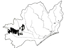
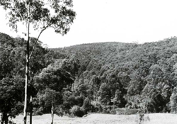
 | Area: 707 sq. km (3.5%) La Trobe land system is mapped on hilly terrain with Ordovician, Devonian and Silurian sediments. It occurs mainly in the south-west of the East Victorian Uplands. Topography is of the ridge-and-ravine type although some ridge crests are rounded; slopes are steep and moderately long. This land is similar geologically and topographically to the Wonnangatta land system but is much more humid. Deep, well-structured soils result from the combination of high rainfall, medium- and fine-grained sedimentary rocks and less-active soil creep. Both gradational and duplex type soils are common, with the former probably dominant. The soils tend to be leached, acidic and probably of low fertility. Shrubby open forest II predominates. The vegetation on protected slopes or in local drainage depressions varies from shrubby or layered open forest III or IV to closed fernland. |  Timbered hillslopes, typical of La Trobe land system, with cleared alluvial terraces in the foreground. |
Rainfall, mean (mm) Temperature, mean (°C) Seasonal growth limitations |
Annual 800 - 1400; lowest January or February (50 - 90), highest August or September (120 - 180) Annual 8 - 12; lowest July (3 - 7), highest February (16 - 20) Temperature <10°C (av.): April - October |
Age, lithology |
Ordovician, Silurian and Devonian sandstones, siltstones and claystones |
Landscape Elevation range (m) Relative relief (m) Drainage pattern Drainage density (km/km2) |
Steep hills with ridge-and-ravine topography 100 - 1080 100 - 260 Dendritic 1.3 |
|
Mostly uncleared: hardwood forestry (minor timber products); apiculture; bush grazing of cattle. Minor proportion cleared: grazing of dairy and beef cattle |
 |  |
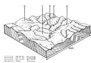
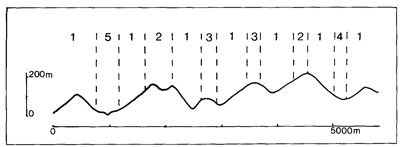
| LAND COMPONENT Percentage of land system Diagnostic features | 1 75 Exposed slopes | 2 10 Protected slopes | 3 5 Broad rounded ridge tops | 4 5 Peat and organic deposits in seepage-fed minor drainage depressions | 5 5 Terraces along major valley flats |
| PHYSIOGRAPHY Slope %, typical and (range) Slope shape | 20-25, (10 - 60) Straight | 20 - 25, (10 - 60) Straight | 5 - 10, (0 - 15) Convex | <2, (0 - 5) Concave | <2, (0 - 5) Straight or concave |
| SOIL | |||||
| Parent material | Mudstone, siltstone, sandstone and shale | Locally derived alluvium and colluvium | Mixed alluvium | ||
| Description | Generally dark sandy loam to sandy clay loam topsoil with crumb structure; yellowish brown or red clay subsoil, acidic and usually with medium blocky structure. Occasionally shallow and stony; profiles gradational or duplex | Shallow peat and mineral soils with high surface organic matter | Variable; red gradational soils; brown undifferentiated stratified sand to sandy clay loams | ||
| Classification | Yellow and Red Podzolic Soils, Lithosols Gn4.11, Gn4.81, Gn4.51, Gn4.64, Gn2.81, Gn3.34, Dy3.21, Dy3.41, Dy5.21, Um4.13, Um6.46 | Brown Earths, Acid Peats Gn4.52, O | Alluvial Soils, Red Earths Gn2.41, Um6.14, Uc1.41 | ||
| Surface texture | Fine sandy loam to clay loam | Sandy loam to clay loam | Sand to sandy clay loam | ||
| Surface consistence | Slightly hard when dry, friable when moist | Friable when moist | Variable | ||
| Depth (m) | 0.8 - 2.0, in places very shallow | >2.0 | >2.0 | ||
| Nutrient status | Low | Low | Low | ||
| Available soil water capacity | Moderate | Moderate | Variable | ||
| Perviousness to water | Slow to moderate | Moderate | Moderate to rapid | ||
| Drainage | Good | Very poor to poor | Often good | ||
| Exposed stone (%) | Generally 0 | 0 | 0 | ||
| Sampled profile number | - | - | - | ||
| NATIVE VEGETATION Structure of vegetation and characteristic species of dominant stratum (+ Predominant species) | Shrubby open forest II: E. sieberi+, E. obliqua+; one or more of E. baxteri E. cypellocarpa, E. radiata, and E. dives usually associated | Shrubby or layered open forest III: E. cypellocarpa+, E. obliqua+, usually with E. radiata, E. sieberi | Shrubby or layered open forest II: E. cypellocarpa+, E. obliqua+, E. sieberi, sometimes E. consideniana+ | Limited data — probably closed fernland of Dicksonia antarctica | Open forest III, IV, often layered: E. viminalis+, E. cypellocarpa, E. obliqua, E. radiata |
Disturbance | Affected process and trend | Primary resultant deterioration | Casual activities | Primary off-site process | ||
Form | Susceptibility of components | Incidence with components | ||||
— reduction in leaf area, rooting depth and/or perenniality
|
resulting in increased deep percolation Decreased root-binding |
Soil creep |
1,2; moderate |
Uncommon |
Accelerated by major disturbance of the native vegetation |
Increased sediment load |
|
|
|
|
|
|
|
|
With reduced infiltration |
Sheet and rill erosion |
4; high 5; moderate 12,3; moderate |
Uncommon |
As for sheet and rill erosion above |
Increased flash flows |
|
|
Streambank erosion |
5; high |
Uncommon |
As for sheet and rill erosion above |
Increased sediment load |
| ||||||


