Collins (Cs)
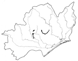
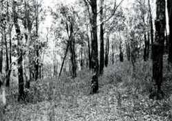
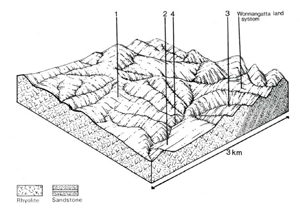
 | Area: 67 sq. km (0.4%) Hilly to undulating terrain on acidic, volcanic rocks, such as the Wellington Rhyolites and intercalated sedimentary rocks, is mapped in Collins land system. Such areas occur at low elevations close to the southern margin of the East Victorian Uplands and along some of the major river valleys. Most of the topography is of the ridge-and-ravine type with short, steep slopes but there are areas with lower relief, rounded ridges and gentler slopes. The valleys of some of the major streams, for example Freestone Creek, have small levees and alluvial terraces similar to those in Walnut land system. Low to moderate rainfall acting on slow-weathering rocks such as rhyolites, rhyodacites and sandstones in a landscape with moderate and steep slopes, leads to a low rate of soil formation but a high rate of natural erosion. The soils therefore, tend to he stony, shallow and acidic and have little profile differentiation. Topsoils have a weak crumb structure while subsoils are usually apedal and earthy. In protected pockets the soils are often deeper and have clayey subsoils. Open forest II dominates, with shrubby open forest III often on more protected slopes and in valleys. The open forests generally give way to woodlands on the rockier slopes. |  Dry. mixed stringybark/box forest with a sparse sclerophyllous understorey and abundant leaf litter. |
| CLIMATE Rainfall, mean (mm) Temperature, mean (°C) Seasonal growth limitations |
Annual 600 - 900; lowest July (40 - 70), highest October (60 - 90) Annual 8 - 12; lowest July (3 - 7), highest February (16 - 20) Temperature <10°C (av.): May - September Rainfall < potential evapotranspiration: November – March |
| GEOLOGY Age, lithology |
Devonian rhyolites (Wellington Rhyolites) and associated mudstones and sandstones; minor Snowy River rhyolites and rhyodacites and intercalated sedimentary rocks |
| PHYSIOGRAPHY Landscape Elevation range (m) Relative relief (m) Drainage pattern Drainage density (km/km2) |
Hilly to undulating terrain 80 - 700 80 - 210 Dendritic 1.3 |
| PRESENT LAND USE |
Minor portion cleared: grazing of cattle |
 |  |
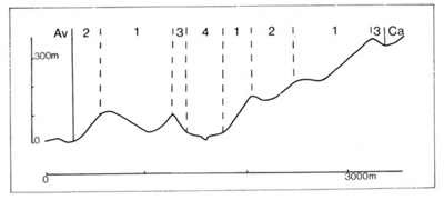
| LAND COMPONENT Percentage of land system Diagnostic features | 1 65 Slopes with dry forest | 2 20 Protected slopes with slightly moister forest than component I | 3 10 Rocky slopes with sharp crests and shallower soils | 4 5 Terraces in major drainage corridors |
| PHYSIOGRAPHY Slope %, typical and (range) Slope shape | 10 - 15, (0 - 30) Variable | 15 - 25, (10 - 40) Concave | 25 - 35, (20 - 60) Straight | 2, (0 - 5) Straight |
| SOIL | ||||
| Parent material | Rhyolite; some mudstone and sandstone; minor rhyodacite | Stony alluvium | ||
| Description | Very dark greyish brown to black loamy sand to sandy clay loam grading into brown or yellowish brown sandy loam to clay loam, or occasionally clay. Generally very stony with rock outcrop in component 3 | Limited observations — undifferentiated brown sand locally underlain by gravel; stone and gravel in stream channels | ||
| Classification | Lithosols. Brown Earths and intergrades: some Yellow Earths. Yellow Podzolic Soils Uc4.11, Uc4.31, Uc5.21, Um6.12. Gn2.81 Gn2.84. Dy3.41 | Alluvial Soils Uc1.23 | ||
| Surface texture | Loamy sand to sandy clay loam | Sand | ||
| Surface consistence | Variable; soft to hard when dry, friable to firm when moist | Loose when dry or moist | ||
| Depth (m) | Mostly0.6 - 1.1, can be less: 0 in areas of rock outcrop | >2.0 | ||
| Nutrient status | Low to moderate | Very low | ||
| Available soil water capacity | Low to moderate | Very low | ||
| Perviousness to water | Moderate | Rapid | ||
| Drainage | Good | Somewhat excessive | ||
| Exposed stone (%) | Very variable; <60 | 0 | ||
| NATIVE VEGETATION Structure of vegetation and characteristic species of dominant stratum (+ Predominant species) | Open forest II: Generally mixed forests with variable composition — including E. consideniana, E. macrorhyncha, E. polyanthemos (one of which usually predominant), E. globoidea, E. muellerana, E. goniocalyx. | Shrubby open forest II, III: Mixed forests with variable composition — including E. cypellocarpa+, E. globoidea+, E. muellerana+, E. polyanthemos+, E. macrorhyncha+ | Shrubby woodland II: Mixed woodlands with variable composition — including E. dives +, E. macrorhyncha+, E. polyanthemos, E. consideniana | Mainly shrubby open forest III, IV: E. viminalis+ with or without E. cypellocarpa+ |
Disturbance | Affected process and trend | Primary resultant deterioration | Casual activities | Primary off-site process | ||
Form | Susceptibility of components | Incidence with components | ||||
— reduction in leaf area, rooting depth and/or perenniality |
|
|
|
|
|
|
|
|
|
|
|
|
|
|
With reduced infiltration |
Sheet and rill erosion |
1,2,3; high |
Not determined |
As for sheet and rill erosion above |
Increased flash flows |
|
|
Streambank erosion |
3; low 4; high |
Not determined |
As for sheet and rill erosion above |
Increased sediment load and turbidity of stream. |
| ||||||


