Baw Baw (BB)
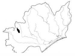
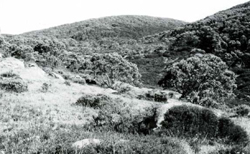
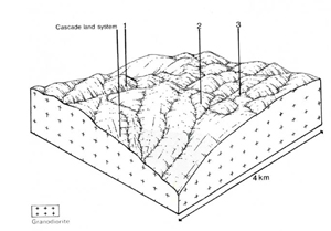
 | Area: 84 sq. km (0.4%) Areas of Baw Baw land system occur in the west of the East Victorian Uplands on plateaux in the subalpine zone. The surfaces of these plateaux are derived from the etch surface which existed below the Mesozoic deeply weathered regolith. Erosion has exposed the fresh granodiorite which is being preferentially dissected along joints in the rock. The terrain is hilly with short, steep slopes, small alluvial flats and frequent bogs. Rocky outcrops, including exfoliating tors, are common. Low temperature and high rainfall combine to produce soils which are friable and acidic, with very high concentrations of organic matter in the topsoil and little textural change down the profile. In spite of excellent infiltration characteristics, surface run-off can occur when the subsoil is frozen or where the soils are relatively shallow. |  Shrubby woodland of Eucalyptus pauciflora (white sallee) and open heath with outcrops of granite tors on the low rounded hills of the Baw Baw Plateau |
| This part of the subalpine tract carries mainly shrubby woodland I or open forest I on more-protected sites. Open heath occurs on rocky and/or exposed sites. A different species composition of open heath occurs on the colluvial footslopes and alluvial flats. Closed sedgeland grows with Sphagnum cristatum in the hogs. | ||
| CLIMATE Rainfall, mean (mm) Temperature, mean (oC) Seasonal growth limitations | Annual 1500 – 2500; lowest January or February (80 - 120); highest August or September (180 - 250) Annual 4-8; lowest July (-2 – 0), highest February (11 – 13) Temperature <100C (av.): April – October Rainfall < potential evapotranspiration: February, frequent winter snow |
| GEOLOGY Age, lithology | Devonian: Baw Baw and Toorongo granodiorite |
| PHYSIOGRAPHY Landscape Elevation range (m) Relative relief (m) Drainage pattern Drainage density (km/km2) | Hilly terrain with joint-based dissection patterns 950 – 1560 160 – 280 Rectangular 1.1 |
| PRESENT LAND USE | Mostly uncleared: mostly within Baw Baw National Park with main uses being nature conservation and recreation – bushwalking and skiing. Small portion cleared for ski runs and ski village. |
 |  |
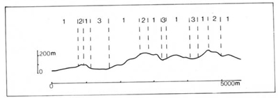
| LAND COMPONENT Percentage of land system Diagnostic features | 1 60 Steep short slopes, often with rock outcrop | 2 25 Crests and less steep upper slopes, often with rock outcrop | 3 15 Footslopes and flats, often with peat hogs and drained by small streams |
| PHYSIOGRAPHY Slope %, typical and (range) Slope shape | 20 - 30. (15 - 60) Straight to convex | 10 - 15, (0 - 30) Convex | <1, (0 - 5) Straight |
| SOIL | |||
| Parent material | Granodiorite | Colluvium and alluvium | |
| Description | Friable black or very dark, organic sandy loam to sandy clay loam, merging into dark brown or dark greyish brown sandy loam to sandy clay loam. May be stony. Variable depth | Black fibrous peat or muck of varying depth overlying mineral soil. Footslopes with soil similar to components 1 and 2 but not stony. | |
| Classification | Alpine Humus Soils/Brown Earths Uc5.21. Uc6.11, Um6.12, Um7.11 | Acid Peats, Humic Gleys. Alpine Humus Soils O, Uc5.21 | |
| Surface texture | Sandy loam to sandy clay loam | Variable | |
| Surface consistence | Soft to slightly hard | - | |
| Depth (m) | 0.5 - 1.2 | >1.0 | |
| Nutrient status | Low to moderate | Very low | |
| Available soil water capacity | Moderate to high | High to very high | |
| Perviousness to water | Moderate to rapid | Moderate | |
| Drainage | Good | Very poor to somewhat poor | |
| Exposed stone (%) | Variable; 0 - 40 | 0 - 5 | |
| Sampled profile number | 5 | - | 3.4 |
| NATIVE VEGETATION Structure of vegetation and characteristic species of dominant stratum (+ Predominant species) | Variable — mainly shrubby woodland I or open forest I, usually of E. pauciflora; occasionally E. glaucescens or Nothofagus cunninghamii. On exposed and/or rocky sites, open heath of Pultenaea muelleri, Helichrysum hookeri and Grevillea australis. Minor occurrences of herbfield of Poa spp., Celmisia asteliifolia and Stylidium graminifolium | Open heath with Richea continentis, Epacris paludosa, E. microphylla and Baeckea gunniana bordering bogs with closed sedgeland of Calorophus lateriflorus, Carex gaudichaudiana. Carex appressa and Sphagnum cristatum | |
Disturbance | Affected process and trend | Primary resultant deterioration | Casual activities | Primary off-site process | ||
Form | Susceptibility of components | Incidence with components | ||||
— reduction in leaf area, rooting depth and/or perenniality |
resulting in: a) increased deep percolation and leaching b) decreased fog drip c) increased rate of snowmelt d) increased depth of soil freezing |
|
|
|
|
|
|
Increased frost heave and soil detachment |
Wind, sheet and rill erosion | 12; low 1.2; moderate | Uncommon Uncommon | Clearing, burning, overgrazing, road building and other earth-moving activities, trafficking by stock and vehicles. |
|
|
With reduced infiltration |
Sheet and rill erosion | 12; moderate - high 3: high 1,2; low | Uncommon; locally severe near construction sites, ski slopes and tracks Uncommon | Increased trafficking by vehicles and humans As for sheet and rill erosion above |
Increased spring and decreased summer stream flow |
|
| Gully and rill erosion Streambank erosion | 1,2; high 3; moderate | Uncommon: locally severe along tracks Uncommon; locally severe | Trafficking by vehicles and humans Trafficking by stock (in the past) and humans |
Increased sediment load and turbidity |
| ||||||


