CLRA03
Location: Marcus Hill, Bellarine Peninsula
Australian Soil Classification: Grey/Yellow Chromosol/Sodosol
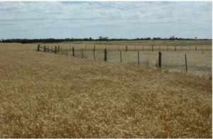
General Landscape Description: Gently undulating plain.
Site Description: Mid slope.
Geology: Neogene Hanson Plain Sand: fluvial gravel, sand, silt.

CLRA3 Landscape. Gently undulating plain of Ocean Grove district.
Soil Profile Morphology:
Surface Soil
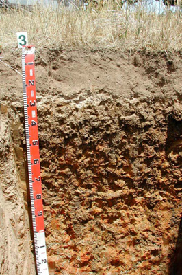
| A11 | 0–5 cm | Dark brown (10YR3/3); fine sandy loam; moderate medium polyhedral structure; rough fabric; very weak consistence dry; pH 5.5; smooth abrupt boundary to: |  CLRA3 Profile CLRA3 Profile | |||
| A12 | 5–20 cm | Dark greyish brown (10YR4/2); fine sandy loam; weak medium polyhedral structure; rough fabric; weak consistence dry; pH 6.0; wavy clear boundary to: | ||||
| A2 | 20–30 cm | Light yellowish brown (10YR6/4); conspicuous bleach (10YR8/2); loamy sand; apedal massive structure; earthy fabric; very firm consistence dry; few ferric concretions; pH 6.5; wavy abrupt boundary to: | ||||
| Subsoil | ||||||
| B21 | 30–50 cm | Dark greyish brown (10YR4/2) with common medium brown and red (10YR5/4, 2.5YR5/6) distinct mottles; medium clay; weak coarse columnar, parting to strong medium prismatic structure; smooth fabric; very strong consistence dry; pH 7.0; wavy gradual boundary to: | ||||
| B22 | 50–110 cm | Light yellowish brown (10YR6/4) with many large red and brown (2.5YR5/6, 10YR4/2) prominent mottles; silty medium clay; strong medium and fine prismatic structure; smooth fabric; few distinct slickenslide cutans and many prominent clay skin and other cutans; strong consistence dry; pH 8.5; wavy diffuse boundary to: | ||||
| B23/B3 | 110–140+ cm | Light yellowish brown (10YR6/3) with many large pale and red (2.5YR5/6) prominent mottles; light medium clay; strong medium prismatic structure; smooth fabric; few prominent clay skin and other cutans; strong consistence dry; pH 8.5. | ||||
Soil Profile Characteristics:
Horizon | Sample Depth (cm) | pH (water) | pH (CaCl2) | EC 1:5 | Exchangeable Cations | |||
Ca | Mg | K | Na | |||||
meq/100g | ||||||||
A11 | 0–5 | 5.4 | 4.8 | 0.16 | 3.3 | 1.4 | 0.9 | 0.39 |
A12 | 5–20 | 5.4 | 4.9 | 0.12 | 2.4 | 0.95 | 0.46 | 0.34 |
A2 | 20–30 | 5.7 | 5 | 0.05 | 1.2 | 0.62 | 0.13 | 0.19 |
B21 | 30–50 | 6.4 | 5.6 | 0.14 | 6.4 | 8.3 | 1.2 | 1.2 |
B22 | 50–110 | 7.2 | 6.6 | 0.19 | 4.9 | 9.2 | 0.78 | 1.9 |
B23 | 110–140 | 7.7 | 6.9 | 0.22 | 3.2 | 8.6 | 0.58 | 2.7 |
Horizon | Sample Depth (cm) | Exchangeable Aluminium mg/kg | Exchangeable Acidity cmolc/kg | Field Capacity pF2.5 | Wilting Point pF4.2 | Coarse Sand (0.2- 2.0 mm) | Fine Sand (0.02- 0.2 mm) | Silt (0.002- 0.02 mm) | Clay (<0.002 mm) |
A11 | 0–5 | <10 | 9.4 | 16.6 | 9.6 | 19 | 59.3 | 6.5 | 8 |
A12 | 5–20 | <10 | 8 | 17.2 | 5.1 | 15.2 | 63.3 | 7 | 9 |
A2 | 20–30 | <10 | 3.6 | 15.6 | 3.4 | 14.9 | 65.8 | 9 | 7 |
B21 | 30–50 | <10 | 9.9 | 43.9 | 29.2 | 2.9 | 11.8 | 4 | 78 |
B22 | 50–110 | 49.1 | 30.7 | 3.3 | 10.1 | 3 | 80.5 | ||
B23 | 110–140 | 43.7 | 26.7 |
Management Considerations:
- This soil has a very strong texture contrast between the surface soil and the subsoil. This can have a major effect by reducing and/or redirecting the internal drainage and restricting root growth due to greater resistance, gas and water throttles as well as associated chemical deterrents to growth. Options include reduced tillage, improving organic matter content and altering the subsoil through artificial drainage (ripping, mole drainage) and/or chemical amelioration (gypsum) to improve structure.
- Mottling usually indicates periodic waterlogging.
- The upper soil is very light and is dependent on maintaining or increasing organic matter levels (OC: A11; 4.8%, A12;1.9% ) to reduce the susceptibility to sheet and rill erosion(in conjunction with slope) as well as increasing the low water holding and nutrient holding capacity.
- The pH of the upper soil is low [strongly acidic below 5.5 (water based)] which will restrict the uptake of some nutrients and increase the susceptibility to aluminium toxicity, while the increasingly alkaline subsoil may pose other restrictions at depth such as increasing sodicity.
- The upper soil has slight dispersibility [Emerson class3(1)] but increases to moderate with depth [Emerson class3(4)].
Source: Robinson et al (2003) A land resource assessment of the Corangamite region. Department of Primary Industries, Centre for Land Protection Research Report No. 19


