
CLRA14
|
| CLRA14 | 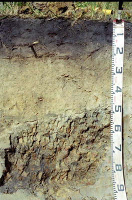 Mesotrophic, Mottled-subnatric, Brown Sodosol | |
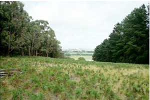
| Deans Marsh (Cemetery Road), Otway Ranges, south-west Victoria | |||
| Hills | |||
| Palaeogene Eastern View Formation: fluvial gravel, sand, clay, brown coal | |||
| Crest | |||
| 4% | |||
| West-north-west | |||
Horizon | Depth (cm) | Description | ||
A1 | 0–15 | Black (10YR2/1), grey (10YR5/1 dry); sandy loam; apedal single grain structure; weak consistence (dry); pH 5.25; clear smooth boundary to: | ||
A2 | 15–50/65 | Light olive brown (2.5Y5/4), pale yellow (2.5Y7/3 dry); sandy loam; apedal massive structure; firm consistence (dry); pH 6.0; abrupt wavy boundary to: | ||
B21 | 50/65–100+ | Yellowish brown (10YR5/6) with common medium and fine prominent and distinct dark yellowish brown (10R4/8) mottles; medium heavy clay; strong very coarse and coarse prismatic, parting to medium polyhedral structure; smooth ped fabric; strong consistence (dry); clay skin cutans; pH 6.0; boundary to: | ||
B/C | 100+ | Yellow (10YR7/6) with common medium and fine prominent and distinct reddish yellow (7.5YR6/8) mottles; apedal massive structure; clay skin cutans; cemented sandstone duripan. | ||
| Management considerations | ||||
This soil is strongly texture contrast which results in the altered movement of water and gases between the light surface, subsurface and the heavy subsoil, the latter also being sodic and having the propensity to disperse and block pores [Emerson 2(1)]. The subsurface soil is quite deep but no structure and eluviated (leached) with little nutrient available, as highlighted by pale colour and low pH. The surface soil has a low pH (acidic) which restricts nutrient availability and increases aluminium and iron availability (leading to toxicity). The organic matter of the surface soil (8.7% OM) is useful in holding both water and nutrients. The surface and subsurface soils are slightly dispersive [Emerson 3(1) and 3(2)]. The heavy subsoil has restricted drainage as evidenced by mottling and matrix colour (pale). The variability of depth to subsoil is useful to know for estimating plant root restrictions and subsurface water movement. | ||||
Site CLRA14 | Sample depth | pH | EC | NaCl | Ex Ca | Ex Mg | Ex K | Ex Na | Ex Al | Ex Acidity | FC –10kPa | PWP –1500kPa | KS | FS | Z | C | |
Horizon | cm | H2O | CaCl2 | dS/m | % | cmolc/kg | cmolc/kg | cmolc/kg | cmolc/kg | mg/kg | cmolc/kg | % | % | % | % | % | % |
A1 | 0–10 | 4.7 | 4 | <0.05 | N/R | 1.1 | 0.69 | 0.12 | 0.1 | 120 | 13 | 17.5 | 6.0 | 28.7 | 43.1 | 5 | 15.5 |
A2 | 30–40 | 5.2 | 4.5 | <0.05 | N/R | 0.35 | 0.28 | 0.09 | 0.09 | 85 | 5.1 | 18.6 | 3.8 | 29.1 | 51.8 | 1 | 14.5 |
B21 | 60–80 | 5.7 | 4.6 | 0.07 | N/R | 0.8 | 5.8 | 0.09 | 0.99 | 120 | 10 | 32.8 | 22.1 | 2.8 | 28.6 | 5 | 59.5 |
© State of Victoria (Agriculture Victoria) 1996 - 2025.

This work, Victorian Resources Online, is licensed under a Creative Commons Attribution 4.0 licence. You are free to re-use the work under that licence, on the condition that you credit the State of Victoria (Agriculture Victoria) as author, indicate if changes were made and comply with the other licence terms.
The licence does not apply to ‘branding’ or some ‘images or photographs’ that may be owned by third parties. We ask you to seek prior approval to use images using the VRO feedback form. Access to higher quality images can also be provided on request.
This page was last updated on 23/03/2020.