
CLRA11
|
| CLRA11 | 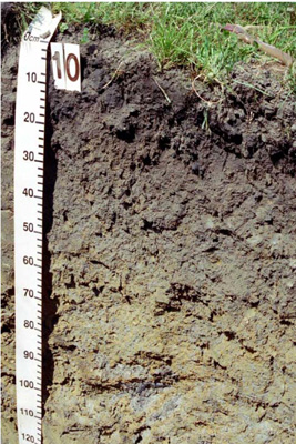 | |
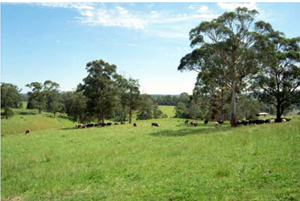
| Kennedys Creek (Lavers Hill Cobden Road), Otway Ranges, south-west Victoria | |||
| Low hills | |||
| Neogene Gellibrand Marl: marine silty clay, clayey silt, calcareous, minor calcarenite | |||
| Mid slope | |||
| 165% | |||
| North-north-east | |||
Horizon | Depth (cm) | Description | ||
A1 | 0–20 | Very dark grey (10YR3/1); sandy clay loam; strong coarse and medium blocky, parting to fine and very fine polyhedral structure; rough ped fabric; strong consistence (dry); non-calcareous, pH 6.0; clear smooth boundary to: | ||
B21g | 20–50 | Very dark greyish brown (2.5Y3/2) with common medium distinct brownish yellow (10YR6/8) mottles; light medium clay; strong fine to medium polyhedral structure; smooth ped fabric; strong consistence (dry); non-calcareous, pH 5.5; gradual smooth boundary to: | ||
B22g | 50–85 | Greyish brown (2.5Y5/2) with many coarse prominent yellowish brown (10YR5/6) mottles; medium heavy clay; strong fine to medium polyhedral structure; smooth ped fabric; strong consistence (dry); non-calcareous, pH 5.5; gradual irregular boundary to: | ||
B23g | 85–130+ | Greyish brown (2.5Y5/2) with many coarse prominent yellowish brown (10YR5/6) mottles; medium clay; strong very fine lenticular structure; smooth ped fabric; strong consistence (dry); non-calcareous, pH 5.5. | ||
| Management considerations | ||||
| This soil is similar to that described by CLRA10, it is gradational with limited texture change with depth and gradational horizon boundaries. The weak structure contributes to the imperfect drainage of the soils as evidenced by subsoil mottling and colour. Other influences on drainage include rainfall and topographic position; here on a mid slope receiving moisture from upslope. Texture and soil stability indicies were not recorded but regarded as similar to CLRA10 where fine sand is a dominant component of this soil and the soil is quite stable (Emerson class 5 for subsoil) though a little less so for the B1horizon (Emerson class 3(1) for subsoil). The high organic matter content of the surface (9.9% OM) and the upper subsoil (1.9% OM) aids stability. The surface soil is slightly limited in depth and therefore restricting as a seedbed. The lower pH in the subsoil will restrict the availability of some nutrients (less calcium) and increase the availability and mobility of aluminium, while the higher surface pH is a result of management intervention to improve nutrient availability. | ||||
Site CLRA11 | Sample depth | pH | EC | NaCl | Ex Ca | Ex Mg | Ex K | Ex Na | Ex Al | Ex Acidity | FC –10kPa | PWP –1500kPa | KS | FS | Z | C | |
Horizon | cm | H2O | CaCl2 | dS/m | % | cmolc/kg | cmolc/kg | cmolc/kg | cmolc/kg | mg/kg | cmolc/kg | % | % | % | % | % | % |
A1 | 0–20 | 5.8 | 5.1 | 0.14 | N/R | 9.7 | 3.3 | 0.41 | 0.53 | N/R | 15 | N/R | N/R | N/R | N/R | N/R | N/R |
B21g | 20–50 | 5.3 | 4.5 | 0.08 | N/R | 4.4 | 4.8 | 0.47 | 0.44 | N/R | 12 | N/R | N/R | N/R | N/R | N/R | N/R |
B22g | 50–85 | 4.9 | 4.1 | 0.14 | N/R | 3.7 | 6.1 | 0.5 | 0.73 | N/R | 16 | N/R | N/R | N/R | N/R | N/R | N/R |
B23g | 85–130+ | 5.2 | 4.1 | 0.11 | N/R | N/R | N/R | N/R | N/R | N/R | N/R | N/R | N/R | N/R | N/R | N/R | N/R |
© State of Victoria (Agriculture Victoria) 1996 - 2025.

This work, Victorian Resources Online, is licensed under a Creative Commons Attribution 4.0 licence. You are free to re-use the work under that licence, on the condition that you credit the State of Victoria (Agriculture Victoria) as author, indicate if changes were made and comply with the other licence terms.
The licence does not apply to ‘branding’ or some ‘images or photographs’ that may be owned by third parties. We ask you to seek prior approval to use images using the VRO feedback form. Access to higher quality images can also be provided on request.
This page was last updated on 23/03/2020.