
Temperature and Evaporation
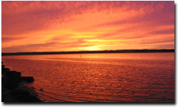 Sunrise over the Curdies River at Peterborough (photograph: Mark Imhof). | Evaporation across the region is also closely related to altitude and latitude (solar radiation). Only four Bureau of Meteorology evaporation stations are situated in the Corangamite region. The seasonal balance between rainfall and evaporation is a critical factor in the hydrologic budget for salinity studies. Areas where evaporation exceeds rainfall for most months of the year are more likely to accumulate evaporative salts in the soil profile. |
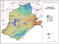 Average Total Annual Evaporation | This map has been developed by Peter Dahlhaus and Tony Davidson, using ANUCLIM, a climatic model developed by the Centre for Resource and Environmental Studies at the Australian National University. The model uses 300 X 300 metre grid cells. Original data was provided by the Bureau of Meteorology. The map provides an overview of the Total Average Annual Evaporation across the region. |
© State of Victoria (Agriculture Victoria) 1996 - 2025.

This work, Victorian Resources Online, is licensed under a Creative Commons Attribution 4.0 licence. You are free to re-use the work under that licence, on the condition that you credit the State of Victoria (Agriculture Victoria) as author, indicate if changes were made and comply with the other licence terms.
The licence does not apply to ‘branding’ or some ‘images or photographs’ that may be owned by third parties. We ask you to seek prior approval to use images using the VRO feedback form. Access to higher quality images can also be provided on request.
This page was last updated on 23/03/2020.