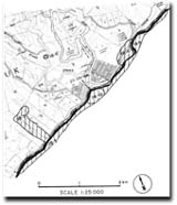
18.5 Skenes Creek Monocline
This information has been developed from the publications:
|
| Location: | 18-33090 to 382112. Shore platform outcrops between Wild Dog Creek and Browns Creek, and road cuttings on the Skenes Creek Road. | |
Access: | From Great Ocean Road. | |
Ownership: | Crown land. | |
Geology: | The thin bedded sandstones and mudstones that form the shore platform between Wild Dog Creek and Browns Creek strike generally parallel to the shore and dip seaward at 20o. In the road cuttings the dips are steeper (70o). The structure has been interpreted as a monocline and named the Skenes Creek Monocline by Edwards (1962). See also Site 18.6 - Skenes Creek Black Coal. | |
Significance: | Regional. The outcrops are a clear example of the monoclinal structure which determines the orientation of the coastline adjacent to Skenes Creek. | |
References: | Edwards, A. B. (1962). "Notes of the geology of the Lorne district, Victoria." Proc. R. Soc. Vict., 74: pp. 101-119. Medwell, G. J. (1971). "Structure of the Otway Ranges in the Otway Basin of South-eastern Australia." (eds. H. Wopfner, and J.G. Douglas). Spec. Pub. geol. Survs. S. Aust. and Vict.:339-362. | |
 Site 18.5 |


