20.2 Point Sturt - Shore Platform and Terrace
|
This information has been developed from the publications:
|
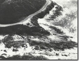
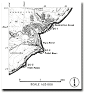
| Location: | 20-518188. One kilometre south east of Wye River. |  Jointing and minor faulting in Otway Group at Point Sturt. |
Access: | Great Ocean Road. | |
Ownership: | Crown land. | |
Geomorphology: | The shore platform here has three low ramparts dipping seaward at 12o and consisting of massive arkose beds (Gill, 1972). The platform is backed by a narrow terrace surveyed by Gill (1972). Several features of this terrace, e.g. its level surface, cavitation weathering on the outer slopes, and abandoned channels (partly boulder filled) cut into the edge, suggest it is an emerged former shore platform representing a 7.5 metre higher sea level during the Last Glacial stage (Gill, 1972). | |
Significance: | International. The assemblage of features described make this a major site to study abandoned shore line and inter-tidal features. As some doubt is attached to the mechanism of shore platform development, the site assumes great significance as an easily accessible one to observe these processes. It is an important locality in the global network of Pleistocene higher sea level sites. | |
Reference: | Gill, E. D. (1972). "The relationship of present shore platforms to past sea levels." Boreas 1:1-25. Gill, E. D. (1972). "Ramparts on shore platforms." Pacific. Geol. 4:121-132. | |


