
23.12 Point Flinders
|
This information has been developed from the publications:
|
| Location: | 23-162974. Two kilometres west of Cape Otway lighthouse. | 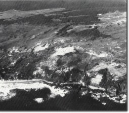 Point Flinders. Pleistocene and Holocene dunes overlie Mesozoic and Tertiary rocks. Arrow indicates tufa wall. |
Access: | Walk from rear of lighthouse reserve at end of Cape Otway Road. | |
Ownership: | Crown land (Otway National Park) and private land. | |
Geology/Geomorphology: | Mesozoic sediments underlie Cape Otway, and the broad configuration of the coast is determined by the structure and lithology of these rocks. Point Flinders is the westernmost exposure of the Mesozoic in the Cape Otway area and the rocks outcrop continuously at the coast to the east. Wilkinson (1865) describes "..... a fossil tree .... embedded horizontally in the Carbonaceous (i.e. Mesozoic) sandstone on the coast about a mile and a half west of Cape Otway. ...... this is the finest specimen I have observed". The site was not located in this survey. Just north of Point Flinders a small poorly exposed outcrop of clays has been referenced as the Glen Aire Clay (Abele et al. in Douglas and Ferguson, 1976). Overlying the Mesozoic and Tertiary rocks is a sequence of Pleistocene dune limestones and younger dune sands. The contact between these is observed high in the cliff face south west of Point Flinders. The lower beds of the dune limestones have been strongly indurated and they form a hard irregular pavement at the cliff top where unconsolidated sands have been blown away. At the cliff edge, they outcrop as a vertical escarpment above the less regular slopes developed on the Mesozoic rocks. Several springs issue from the base of the dune limestone and where they emerge at the cliff face form tufa deposits over the Mesozoic rocks. A magnificent tufa wall has been built by this process. | |
Significance: | State. This site is an important one for displaying the contact between Mesozoic and Quaternary sediments. Several features of the dune limestone are of particular significance including the tufa wall, the limestone pavements and the climbing dunes one kilometre northwest of Point Flinders. These clearly illustrate the process of development of clifftop dunes being moved up an escarpment and onto a platey surface. | |
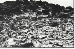 Rubble calcarenite surface in cliff-top dunes east of Point Flinders. |  Point Flinders |
© State of Victoria (Agriculture Victoria) 1996 - 2025.

This work, Victorian Resources Online, is licensed under a Creative Commons Attribution 4.0 licence. You are free to re-use the work under that licence, on the condition that you credit the State of Victoria (Agriculture Victoria) as author, indicate if changes were made and comply with the other licence terms.
The licence does not apply to ‘branding’ or some ‘images or photographs’ that may be owned by third parties. We ask you to seek prior approval to use images using the VRO feedback form. Access to higher quality images can also be provided on request.
This page was last updated on 23/03/2020.