
14.8 Pebble Point (Point Margaret to Point Lucton)
|
This information has been developed from the publications:
|
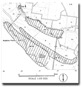
| Location: | 14-899104. The site extends along the coast from two kilometres to six kilometres south-east of the mouth of the Gellibrand River. |  Coastal profile and slump terraces in Tertiary sediments overlying Mesozoic rocks at Pebble Point. |
| Access: | Track from Moonlight Head Road near "Rivernook" or beach walk from mouth of Gellibrand River. | |
| Ownership: | Crown land (Otway National Park). | |
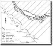
Geology: | This is a major site to display the unconformable contact between the Lower Cretaceous Otway Group and the Lower to Middle tertiary Wangerrip Group. The contact is most easily examined at Point Margaret where it is at beach level, the plane of unconformity rising in the cliff face to the south east at an angle of about 10o. The contact becomes inaccessible for close study south of Pebble Point due to the steepness of the cliffs and obscurance by slump blocks and talus on the cliff face. Two formations, the Pebble Point Formation and the Dilwyn Formation have the type section here, the transitional contact between these being exposed near Point Margaret. A small fault at the cliff base between Point Margaret and Buckleys Point has brecciated arkose along the crush zone. The cliff profiles are composite and the slope angle reflects the differing hardness of the Mesozoic and Tertiary rocks. Three major slope sequences occur. The lowest sector (in the Mesozoic arkose) is the steepest (50o to 60o) while the angle declines to 40o in the Tertiary formations which are subject to slumping due to subaerial erosion. Baker (1950) drew attention to the remarkable sequence of active slump terraces of the uppermost cliff, described the processes in their formation and classified them as erosion amphitheatres. These active landslip sites play a major role in shaping both the plan and profile configuration of this coastal site. | 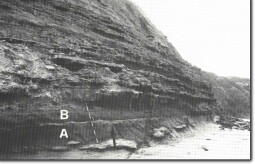 Unconformity (arrowed) between Mesozoic rocks (A) and Tertiary sediments (B) at Point Margaret. |
Significance: | National. The outcrops are the best available for the study of the Mesozoic-Tertiary unconformity, which is one of the major geological boundaries in Victoria. It is a major site for the study and teaching of structural geology, stratigraphy and geomorphology. The erosion amphitheatres are particularly important due to their size, activity, and the control they exercise on coastal form. They are the largest and most extensive set of clearly defined slump terraces on the Victorian coast. | 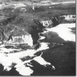 Coastal profile and slump amphitheatres at Bell Point. |
References: | Baker, G. (1950). "Geology and physiography of the Moonlight Head district." Proc. R. Soc. Vict.; 60: pp. 17-44. Baker, G. (1953). "The relationship of Cyclammina bearing sediment to the older Tertiary deposits southeast of Princetown, Victoria." Mem. Nat. Mus. Vict. 18: pp. 125-134. Wopfner, H. & Douglas, J.G. (1971). "The Otway Basin of southeastern Australia." Spec. Bull. geol. Surv. S. Aust: 464 pp. Douglas, J.G. & Ferguson, J. (1976). "Geology of Victoria." Geol. Soc. Aust. Spec. Pub. 5: 528 pp. | |
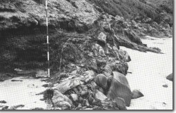 Brecciated zone of small fault contact between Mesozoic and Tertiary sediments at Point Pember. | 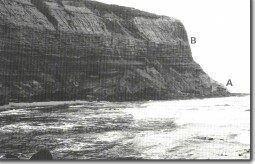 The contact between the Mesozoic (A) and Tertiary rocks (B) rising in the cliff face at Pebble Point. |
© State of Victoria (Agriculture Victoria) 1996 - 2025.

This work, Victorian Resources Online, is licensed under a Creative Commons Attribution 4.0 licence. You are free to re-use the work under that licence, on the condition that you credit the State of Victoria (Agriculture Victoria) as author, indicate if changes were made and comply with the other licence terms.
The licence does not apply to ‘branding’ or some ‘images or photographs’ that may be owned by third parties. We ask you to seek prior approval to use images using the VRO feedback form. Access to higher quality images can also be provided on request.
This page was last updated on 23/03/2020.