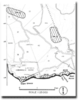
24.3 Parker River
|
This information has been developed from the publications:
|
| Location: | 24-198986. Two kilometres north-east of Lawry Hill. | |
Access: | Private road from Cape Otway Lighthouse Road. | |
Ownership: | Private land and some Crown land. | |
Geomorphology: | The lower course of the Parker River is partly fault aligned but is also deflected to the east by the Quaternary sand dunes moving eastward across Cape Otway. This site shows that the influence of the sand dunes has been slight and there is no evidence of stream blocking, in the form of swamps. No aeolian material occurs on the eastern side of the stream. Probably the rate of sand spilling into the channel was equalled by the capacity of the stream to remove it. | |
Significance: | Regional. This site illustrates a particular geomorphological process similar to that at the mouth of the Johanna River. | |
 Site 24.2 to 24.6 |


