
14.5 Gellibrand River Levee Banks - Princetown
|
This information has been developed from the publications:
|
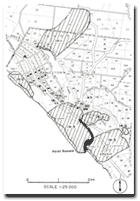
| Location: | 14-888137. The banks and part of the flood plain of the Gellibrand River 1 km east of Princetown. | 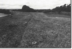 Levee banks of the Gellibrand River near Princetown. |
Access: | From Lower Gellibrand-Princetown River Road. | |
Ownership: | Crown land (River Reserve) and private land. | |
Geomorphology: | The levee banks of the Gellibrand River are unusually distinctive on the floodplain downstream from the Great Ocean Road Bridge at Lower Gellibrand. They rise to 1.5 metres above the flood plain as rounded symmetrical ridges that border the river. A short abandoned reach of the river also has well preserved levee banks. | |
Significance: | State. These are some of the best examples of levee banks on a confined floodplain in Victoria. | |
© State of Victoria (Agriculture Victoria) 1996 - .

This work, Victorian Resources Online, is licensed under a Creative Commons Attribution 4.0 licence. You are free to re-use the work under that licence, on the condition that you credit the State of Victoria (Agriculture Victoria) as author, indicate if changes were made and comply with the other licence terms.
The licence does not apply to ‘branding’ or some ‘images or photographs’ that may be owned by third parties. We ask you to seek prior approval to use images using the VRO feedback form. Access to higher quality images can also be provided on request.
This page was last updated on .