
14.1 La Trobe Creek and escarpment - Princetown
|
This information has been developed from the publications:
|
| Location: | 14-865174. Two kilometres north of Princetown. | 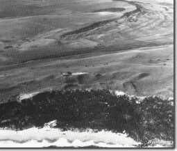 Escarpment (background) in Port Campbell Limestone. Bridgewater Formation dune limestone in foreground capped with Pleistocene dunes. Between the two is the alluvial valley of the La Trobe Creek. |
Access: | Great Ocean Road. | |
Ownership: | Private land on the escarpment and Crown Land adjacent to the creek. | |
Geology/Geomorphology: | This crescent shaped escarpment is a small down faulted outlier of Port Campbell Limestone overlying Gellibrand Marl. Weathered outcrop of the two formations may be seen in the head of small landslips on the escarpment face. The escarpment foot is buried by the swamp and alluvium of the La Trobe Creek, developed subsequent to the submergence of the valley by the Holocene rise of sea level. Low bluffs on the east of the alluvial valley indicate a previous open water or lagoonal situation prior to the blocking of the Gellibrand River mouth by drifting sand. The site is extended to include an example of the high hummocky terrain of La Trobe Creek, that is part of the Pleistocene dune limestone sequence emplaced across the mouth of the Gellibrand River valley. | |
Significance: | Regional. The capping of Port Campbell Limestone is the only extensive occurrence of this formation in the Otway Shire. It accounts for the form of the escarpment which is steeper and more distinctly ridged than adjacent stream divides. The site displays an important sequence of depositional and erosional features (escarpment, bluffs, dune limestone, marine cliffs, alluvial fill and wetland) related to Pleistocene and Holocene sea level changes. | |
© State of Victoria (Agriculture Victoria) 1996 - .

This work, Victorian Resources Online, is licensed under a Creative Commons Attribution 4.0 licence. You are free to re-use the work under that licence, on the condition that you credit the State of Victoria (Agriculture Victoria) as author, indicate if changes were made and comply with the other licence terms.
The licence does not apply to ‘branding’ or some ‘images or photographs’ that may be owned by third parties. We ask you to seek prior approval to use images using the VRO feedback form. Access to higher quality images can also be provided on request.
This page was last updated on .