
16.6 Johanna Heights - Landslip Amphitheatres
|
This information has been developed from the publications:
|
The Aire River valley is one of the major physiographic features of the Otway Ranges. The river drains some of the highest rainfall areas in Victoria and has incised a deep valley into the Mesozoic rocks. There are several long deep gorge sections and sets of rapids and waterfalls. The valley provides a major inland exposure of the Otway Group sediments and the geomorphology of the channel and valley walls is complex and of considerable interest. Two major physiographic divisions of the valley are recognised (a) the incised, narrow valley that includes gorges, rapids and falls; and (b) the flood plain and infilled estuary of the Aire, Calder and Ford Rivers between Hordern Vale, Glenaire and the river mouth.
The area is one of State significance. The outcrops and physiographic features should be preserved with as little disturbance as is consistent with maintaining fire security. Vehicular traffic should be restricted to a defined number of access points and the potential for river and forest based active recreation should be utilised. For many months there is potential for canoeing, and the continuous flow of the river assures water supply for hikers and bushwalkers. It is recommended that no forestry operations, clearing or further roadworks be permitted in the area designated.
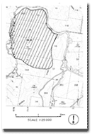
| Location: | 16-065117. Four kilometres south of Lavers Hill. | |
Access: | Johanna River Road. | |
Ownership: | Private land. | |
Geomorphology: | A succession of bowl shaped escarpments at the heads of tributaries of Stafford Creek are considered to be headwall scarps resulting from large landslides. The displaced material has been largely removed by stream action and the streams have incised deep narrow valleys across the escarpments. The resulting topography is one of abrupt changes of slope form and angle and an unusual drainage pattern has developed. | |
Significance: | Regional. This terrain is representative of the southern flank of the Otway Ranges. The headwall escarpments are conspicuous features and illustrate a major and continuing landform process of the region. | |
© State of Victoria (Agriculture Victoria) 1996 - 2025.

This work, Victorian Resources Online, is licensed under a Creative Commons Attribution 4.0 licence. You are free to re-use the work under that licence, on the condition that you credit the State of Victoria (Agriculture Victoria) as author, indicate if changes were made and comply with the other licence terms.
The licence does not apply to ‘branding’ or some ‘images or photographs’ that may be owned by third parties. We ask you to seek prior approval to use images using the VRO feedback form. Access to higher quality images can also be provided on request.
This page was last updated on 23/03/2020.