
22.3 Johanna River Flood plain
|
This information has been developed from the publications:
|
| Location: | 22-056074. One kilometre west of Johanna Beach. | 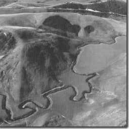 Incised meanders of the Johanna River. |
Access: | From Blue Johanna Road. | |
Ownership: | Private land and some Crown land (River Reserve). | |
Geomorphology: | The lower Johanna River follows an easterly course determined by resistant strata of Otway Group sandstones. Where this sequence has been breached, the Johanna and Stafford Creek have cut a wide valley now alluviated. The streams probably left this sector and flowed into the sea near the present camping ground area but the rivers have been further deflected to the east by the invasion of the valley by transgressive parabolic dunes. The alluvial sector is now further incised by the Johanna which displays tightly curled entrenched flood plain meanders, | |
Significance: | Regional. This forms the only alluvial valley deposit between the Aire and Gellibrand valley. |
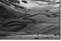 Incised meanders of the Johanna River. |
© State of Victoria (Agriculture Victoria) 1996 - .

This work, Victorian Resources Online, is licensed under a Creative Commons Attribution 4.0 licence. You are free to re-use the work under that licence, on the condition that you credit the State of Victoria (Agriculture Victoria) as author, indicate if changes were made and comply with the other licence terms.
The licence does not apply to ‘branding’ or some ‘images or photographs’ that may be owned by third parties. We ask you to seek prior approval to use images using the VRO feedback form. Access to higher quality images can also be provided on request.
This page was last updated on .