
16.5 Aire River Gorge
|
This information has been developed from the publications:
|
The Aire River valley is one of the major physiographic features of the Otway Ranges. The river drains some of the highest rainfall areas in Victoria and has incised a deep valley into the Mesozoic rocks. There are several long deep gorge sections and sets of rapids and waterfalls. The valley provides a major inland exposure of the Otway Group sediments and the geomorphology of the channel and valley walls is complex and of considerable interest. Two major physiographic divisions of the valley are recognised - (a) the incised, narrow valley that includes gorges, rapids and falls; and (b) the floodplain and infilled estuary of the Aire, Calder and Ford Rivers between Hordern Vale, Glenaire and the river mouth.
The area is one of State significance. The outcrops and physiographic features should be preserved with as little disturbance as is consistent with maintaining fire security. Vehicular traffic should be restricted to a defined number of access points and the potential for river and forest based active recreation should be utilised. For many months there is potential for canoeing, and the continuous flow of the river assures water supply for hikers and bushwalkers. It is recommended that no forestry operations, clearing or further roadworks be permitted in the area designated.
| Location: | 16-152130 to 150070 (Aire River Valley) | 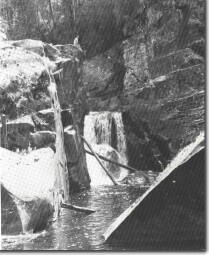 Aire River Falls |
| Access: | Aire Crossing Road; Hall Ridge Road; Heffernan Track; Calder Ridge Road; Holy Water Track. All approaches require a substantial walk along the river or down steep valley side slopes. | |
| Ownership: | Crown land (including some reserved forest). | |
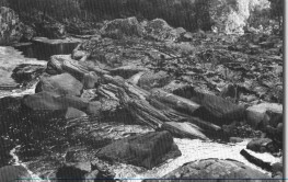
| Geology/Geomorphology: | South from Aire Crossing, the Aire River flows in a gorge of variable depth and width cut into thick bedded Lower Cretaceous sandstones. Maximum dissection is in excess of 200 m in the south before the river emerges abruptly onto the short flood plain near Horden Vale. The river bed falls from 170 m above sea level at Hall Ridge to below 5 m at the Great Ocean Road Bridge at Horden Vale and achieves this via a number of impressive falls, cascades and rapids. The gorge is typically asymmetrical with one steep valley wall including cliffs of sandstone and the opposite wall of lesser slope. Waterfalls and cascades occur where the strike is normal or at a high angle oblique to the channel direction. Jointing may determine the detail of the orientation of channels across a waterfall zone. Where stream orientation is parallel to strike direction the channel is narrow and has marked asymmetry of profile. Potholes of various sizes are common - in some cases these have been initiated where concretions have been removed but elsewhere they are apparently true abrasive potholes. There are long sectors of imbricated boulders but very few areas of smaller gravels. Higher level boulder terraces occur. Several very large tor size boulders are strewn across the channel below a gorge sector at map reference 152084. | |
Significance: | State. This is the most rugged river gorge in the Shire of Otway and a major physiographic feature of the Otway Ranges. The extensive outcrop, clearly displayed structural features and geomorphic processes operating on the sedimentary bedrock warrant the preservation of this valley as a high priority - also see comments above. | 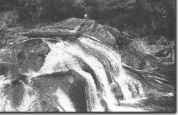 Cascades on the Aire River. Dip of sandstone is upstream at the falls. |
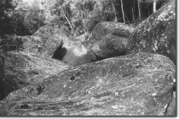 Tor size boulders in Aire River gorge | 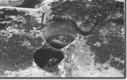 Potholes with grinding boulders in place - Aire River gorge | 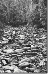 Imbricate boulder in Aire River gorge |
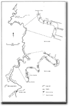 Aire River Gorge | 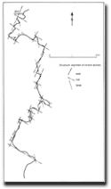 Aire River Gorge | 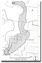 Site 16.4 & 16.5 |
|
© State of Victoria (Agriculture Victoria) 1996 - 2025.

This work, Victorian Resources Online, is licensed under a Creative Commons Attribution 4.0 licence. You are free to re-use the work under that licence, on the condition that you credit the State of Victoria (Agriculture Victoria) as author, indicate if changes were made and comply with the other licence terms.
The licence does not apply to ‘branding’ or some ‘images or photographs’ that may be owned by third parties. We ask you to seek prior approval to use images using the VRO feedback form. Access to higher quality images can also be provided on request.
This page was last updated on 23/03/2020.