
4.1 Gellibrand River Tributary
|
This information has been developed from the publications:
|
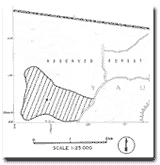
| Location: | 4-193366. Five kilometres north west of Gellibrand. | |
Access: | Wonga Road. | |
Ownership: | Crown land (Reserved Forest). | |
Geology /Geomorphology: | The site includes small tributary creeks of the Gellibrand River incised into deeply leached sands of the Dilwyn Formation. The drainage divides are of varied form including a small area of plateau in the south west that supports a wet heath vegetation. | |
Significance: | Local. The small plateau represents the former topography of the surface into which the drainage system is now incised. | |
© State of Victoria (Agriculture Victoria) 1996 - .

This work, Victorian Resources Online, is licensed under a Creative Commons Attribution 4.0 licence. You are free to re-use the work under that licence, on the condition that you credit the State of Victoria (Agriculture Victoria) as author, indicate if changes were made and comply with the other licence terms.
The licence does not apply to ‘branding’ or some ‘images or photographs’ that may be owned by third parties. We ask you to seek prior approval to use images using the VRO feedback form. Access to higher quality images can also be provided on request.
This page was last updated on .