
8.1 Gellibrand River - Terrace
|
This information has been developed from the publications:
|
| Location: | 8-115341. Six kilometres north of Carlisle River on the south bank of the river. | |
Access: | Black Bridge Road or Bunker Hill Road. | |
Ownership: | Private land. | |
Geomorphology: | The terrace extends for 400 m and average 75 m wide. An old landslip partly covers the western section of the terrace. | |
Significance: | Regional. Alluvial terraces are not common on this part of the Gellibrand River. | |
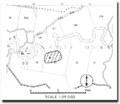 Site 8.1 |
© State of Victoria (Agriculture Victoria) 1996 - .

This work, Victorian Resources Online, is licensed under a Creative Commons Attribution 4.0 licence. You are free to re-use the work under that licence, on the condition that you credit the State of Victoria (Agriculture Victoria) as author, indicate if changes were made and comply with the other licence terms.
The licence does not apply to ‘branding’ or some ‘images or photographs’ that may be owned by third parties. We ask you to seek prior approval to use images using the VRO feedback form. Access to higher quality images can also be provided on request.
This page was last updated on .