
10.2 Gellibrand River - Valley Form and Landslips at Upper Gellibrand
This information has been developed from the publications:
|
| Location: | 10-302297 and 10-307287. One kilometre north east of Upper Gellibrand. | |
Access: | Ridge Road. | |
Ownership: | Private land. | |
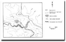
Geomorphology: | This steep valley section of the Gellibrand River displays several stages of landslip development. Adjacent to Ridge Road in the north of the site is a depression high on the slope which is probably a back tilt block of an old landslip. Two hundred and fifty metres south of Roadnight Creek Road junction is a group of recently active landslips that extend from the ridge crest to the valley floor. Two wind gaps on the ridge north of the main landslip may be high level abandoned channel segments of the river. | |
Significance: | Regional. The landslips and wind gaps demonstrate the process of valley development on the upper Gellibrand River. The youngest landslips probably postdate land clearing. | |
 Site 10.2 |  Sites 10.2 and 10.3 |
© State of Victoria (Agriculture Victoria) 1996 - .

This work, Victorian Resources Online, is licensed under a Creative Commons Attribution 4.0 licence. You are free to re-use the work under that licence, on the condition that you credit the State of Victoria (Agriculture Victoria) as author, indicate if changes were made and comply with the other licence terms.
The licence does not apply to ‘branding’ or some ‘images or photographs’ that may be owned by third parties. We ask you to seek prior approval to use images using the VRO feedback form. Access to higher quality images can also be provided on request.
This page was last updated on .