
14.2 Gellibrand Marl - Type Section
|
This information has been developed from the publications:
|
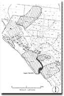
| Location: | 14-155858. Coastal cliffs two to three kilometres north-west of the mouth of the Gellibrand River. | |
Access: | Off Great Ocean Road 100 metres west of the bridge over La Trobe Creek. | |
Ownership: | Crown land (Port Campbell National Park). | |
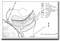
Geology: | This site includes the type section for the Gellibrand Marl which is a marine formation of early Miocene age. The coastal cliffs provide the best exposures of these rocks in the Otway Shire, the section consisting of thin beds of fossiliferous grey and blue clays. Access to the sections is difficult due to the steep cliffs and large fallen blocks from the overlying dune limestone. | |
Significance: | State. The locality has been the subject of several papers discussing the Tertiary stratigraphy of the Otway Basin and should be available to students and research workers. | |
References: | Wilkinson, C.S. (1865). "Report on the Cape-Otway country." (From Parl. Papers 1865-65.) Rep. geol. Surv. Vict. Murray, R.A.F. (1877). "Report on the geology of portions of the Cape Otway district." Rep. Progr. geol. Surv. Vict. 4: pp. 11-12. Baker, G. (1944). "The geology of the Port Campbell district." R. Soc. Vict. 56: 76-108. Baker, G. (1953). "The relationship of Cyclammina bearing sediment to the older Tertiary deposits southeast of Princetown, Victoria." Mem. Nat. Mus. Vict. 18: pp. 125-134. Wopfner, H. & Douglas, J.G. (1971). "The Otway Basin of southeastern Australia." Spec. Bull. geol. Surv. S. Aust: 464 pp. Douglas, J.G. & Ferguson, J. (1976). "Geology of Victoria." Geol. Soc. Aust. Spec. Pub. 5: 528pp. | |
© State of Victoria (Agriculture Victoria) 1996 - 2025.

This work, Victorian Resources Online, is licensed under a Creative Commons Attribution 4.0 licence. You are free to re-use the work under that licence, on the condition that you credit the State of Victoria (Agriculture Victoria) as author, indicate if changes were made and comply with the other licence terms.
The licence does not apply to ‘branding’ or some ‘images or photographs’ that may be owned by third parties. We ask you to seek prior approval to use images using the VRO feedback form. Access to higher quality images can also be provided on request.
This page was last updated on 23/03/2020.