
9.1 Gellibrand River - High level prior channel
|
This information has been developed from the publications:
|
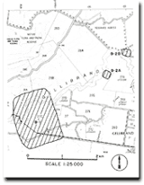
| Location: | 9-183328. Three kilometres west of Gellibrand. | 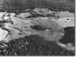 Gellibrand river terraces and abandoned channel. |
Access: | Carlisle-Gellibrand Road. | |
Ownership: | Private land. | |
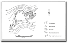
Geomorphology: | The Gellibrand River describes a broad entrenched meander downstream from a narrow flood plain sector with three levels of terraces. The topography of the spur and the meander form suggest that a prior higher level river channel extended across the spur. Kenny (1938) reported an outcrop of brown coal in the river bank here. | |
Significance: | Regional. The site is of interest in determining the rates of channel incision along different sectors of the Gellibrand River. The river terraces and the high level channel are of importance in this determination. | |
References: | Kenny, J.P.L. (1938). "Geology of the Kawarren - Gellibrand district." Min. geol. J. Vict. 1(3): 76-79. | |
© State of Victoria (Agriculture Victoria) 1996 - .

This work, Victorian Resources Online, is licensed under a Creative Commons Attribution 4.0 licence. You are free to re-use the work under that licence, on the condition that you credit the State of Victoria (Agriculture Victoria) as author, indicate if changes were made and comply with the other licence terms.
The licence does not apply to ‘branding’ or some ‘images or photographs’ that may be owned by third parties. We ask you to seek prior approval to use images using the VRO feedback form. Access to higher quality images can also be provided on request.
This page was last updated on .