
24.2 E. S. Hill - Precipitation Ridge
|
This information has been developed from the publications:
|
| Location: | 24-176998. Four kilometres north of Cape Otway. | |
Access: | Private track off Cape Otway Lighthouse Road. | |
Ownership: | Private land. | |
Geomorphology: | A high stabilised sand ridge marks the inner limit of calcareous dune sands north of Cape Otway. The ridge has a steep northern slope. This is the old precipitation face where sand spilled north when the large dune complex to the south and west was being emplaced by wind action. | |
Significance: | Regional. The site is representative of one of the major geological and geomorphological boundaries in the Otway Shire. | |
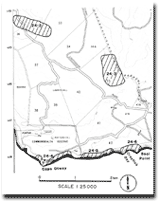 Site 24.2 to 24.6 |
© State of Victoria (Agriculture Victoria) 1996 - .

This work, Victorian Resources Online, is licensed under a Creative Commons Attribution 4.0 licence. You are free to re-use the work under that licence, on the condition that you credit the State of Victoria (Agriculture Victoria) as author, indicate if changes were made and comply with the other licence terms.
The licence does not apply to ‘branding’ or some ‘images or photographs’ that may be owned by third parties. We ask you to seek prior approval to use images using the VRO feedback form. Access to higher quality images can also be provided on request.
This page was last updated on .