
23.7 Eagle Nest Rock, Sentinel Rock and Aire Calcarenites
|
This information has been developed from the publications:
|
The confluence of the Aire, Calder and Ford rivers provide the largest alluvial basin in the Otway shire. The basin is in part structural occupying the downthrown side of the Castle Cove Fault (Singleton, 1967), and in part erosional, having been enlarged by fluvial processes during Pleistocene glacial low sea level episodes. During interglacial higher sea level periods, the basin was flooded by the sea and the previously defined margins were extended by marine erosion. The basin is underlain by Otway Group sediments which now outcrop around the northern and eastern edges forming the distinctive ridge and valley terrain of the southern Otway Ranges.
As with the Johanna area, the Aire basin illustrates a Tertiary depositional sequence that differs from the major part of the Otway basin to the west. Attempts have been made therefore to establish a local scheme of rock nomenclature (reviewed in Douglas and Ferguson, 1976) and further detailed work is being undertaken (e.g. Marshallsea, 1982; Tingate, 1982).
Although the best outcrops of Tertiary strata are found in sites adjacent to the Aire (e.g. Castle Cove), several important stratigraphical sections occur on the coast near the Aire mouth and in cliffs fringing the floodplain.
Quaternary sediments in the Aire basin are complex and include shallow marine, estuarine, lagoonal and tidal sands, muds and shells, floodplain and lacustrine deposits and windblown sand. These record the changing environments (tectonic, climatic, marine) over the Pleistocene and Holocene and provide a major opportunity for studies in palaeoecology, geomorphology and prehistory.
The geomorphology of the Aire basin is dominated by three major units:
(a) the sequence of Pleistocene and Holocene calcareous sands that comprise the massive dune ridge that enclosed the basin - the Aire has cut a gorge across this at a time of lower sea level and this gorge is now being filled by aeolian sands;
(b) the Castle Cove Fault which delineates the north western edge of the basin;
(c) the present floodplain of the rivers representing a largely infilled estuary with residual wetlands and lakes.
| Location: | 23-124025 to 136017. Coastal cliffs west of the mouth of the Aire River. | 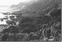 Pitted calcarenite shore platform at the mouth of the Aire River. |
Access: | Coastal walking tracks from Aire camping area. | |
Ownership: | Mainly Crown land (Otway National Park) and some private land. | |
Geology: | The high cliffed coastline west of the Aire river mouth is the seaward margin of a massive sequence of Pleistocene calcareous aeolianites (dune limestones). Several stages of dune formation are evidenced by the varied bedding directions and palaeosols exposed in active cliff sectors. Beneath the dune rock there are outcrops of the Glen Aire Clay, Fishing Point Marl and a dark grey clay with leaf impressions designated the Sentinel Rock Clay by Carter (1958). These exposures are ephemeral being frequently obscured by slumped blocks fallen from the overlying dune limestones. | |
Significance: | Regional. The site illustrates features of part of the largest block of dune limestone in the Otway Shire. The presence of lithified dune sands contrasts with the absence of this material at the Johanna dunes. The Tertiary strata beneath the dunes are of importance in local stratigraphic correlation. | |
References: | Wilkinson, C.S. (1865). "Report on the Cape Otway country." (From Parl. Papers 1864-65). Rep. geol. Surv. Vict. Hall, T.S. & Pritchard, G.B. (1899). "The Tertiary deposits of the Aire and Cape Otway." Proc. R. Soc. Vict. 12: pp. 36-59. Chapman, F. (1904). "On some Cainozoic Foraminifera from Browns Creek, Otway Coast." Rec. geol. Surv. Vict. 1: pp. 227.230. Deane, H. (1904). "Preliminary report on fossil flora." Rec. Geol. Surv. Vict. 1: 13-14. Carter, A.N. (1958). "Tertiary Foraminifera from the Aire district Victoria." Bull. Geol. Surv. Vict. 55. Douglas, J.G. & Ferguson, J. (1976). "Geology of Victoria." Geol. Soc. Aust. Spec. Pub. 5: 528 pp. Singleton, O.P. (1976). "Otway Region. Excursions Handbook." 39th Congr. Aust. N.Z. Assoc. Advmt. Sci. Sect. C. pp. 171-181. Head, L. & Stuart, I. (1980). "Change in the Aire - palaeoecology and prehistory in the Aire basin, southwestern Victoria." Monash Pub. in Geog. 24: pp 102. Marshallsea, S.J. (1982). "The geology of the Johanna River area." B. Sc. Hons. Report (unpub.) Univ. of Melb. Tingate, P. (1982). "The geology of the Aire district." B. Sc. Hons. Report (unpub.) Univ. of Melb. | |
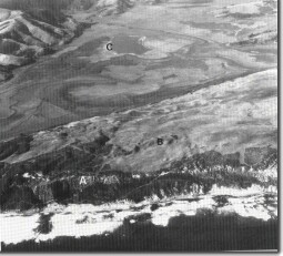 Pleistocene Bridgewater Formation dune calcarenite (A), cliff-top dunes (B), and the Aire River Basin with Lake Hordern (C). | 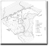 Aire Valley Geomorphology | 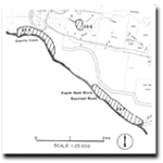 Sites 23.5 to 23.7 |
© State of Victoria (Agriculture Victoria) 1996 - 2025.

This work, Victorian Resources Online, is licensed under a Creative Commons Attribution 4.0 licence. You are free to re-use the work under that licence, on the condition that you credit the State of Victoria (Agriculture Victoria) as author, indicate if changes were made and comply with the other licence terms.
The licence does not apply to ‘branding’ or some ‘images or photographs’ that may be owned by third parties. We ask you to seek prior approval to use images using the VRO feedback form. Access to higher quality images can also be provided on request.
This page was last updated on 23/03/2020.