
14.6 Dilwyn Formation - Princetown Quarry
|
This information has been developed from the publications:
|
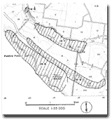
| Location: | 14-901121. Five kilometres south-east of Princetown adjacent to the River Road. | 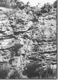 Dilwyn Formation on Princetown-Lower Gellibrand road. Note high angle fault (parallel to pecked line). |
Access: | River Road between Lower Gellibrand and Princetown. | |
Ownership: | Crown land (Road Reserve). | |
Geology: | A small quarry exposes 7 m of yellow and red ferruginous beds of the Dilwyn Formation. A high angle reverse fault is conspicuous in the abandoned quarry face. | |
Significance: | Regional. Exposure of Dilwyn Formation apart from the coastal cliffs are not common and all accessible sites including artificial exposures are regarded as significant. |
© State of Victoria (Agriculture Victoria) 1996 - 2025.

This work, Victorian Resources Online, is licensed under a Creative Commons Attribution 4.0 licence. You are free to re-use the work under that licence, on the condition that you credit the State of Victoria (Agriculture Victoria) as author, indicate if changes were made and comply with the other licence terms.
The licence does not apply to ‘branding’ or some ‘images or photographs’ that may be owned by third parties. We ask you to seek prior approval to use images using the VRO feedback form. Access to higher quality images can also be provided on request.
This page was last updated on 23/03/2020.