
15.1 Chapple Creek Backswamp
|
This information has been developed from the publications:
|
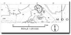
| Location: | 15-023220. Three hundred metres north-west of the road bridge at Chapple Vale. | |
Access: | Mt McKenzie - Chapple Vale Road. | |
Ownership: | Private land. | |
Geomorphology: | The swamp occupies a depression below an old landslip on the north side of the confined floodplain of Chapple Creek. | |
Significance: | Local. Because the swamp is not drained or cleared, it represents the best unmodified flood plain swamp of Chapple Creek. The rate of transmission of water from the valley side through the wetland to the creek illustrates a major process of drainage development on the Tertiary sediments on the north western flank of the Otway Ranges. | |
© State of Victoria (Agriculture Victoria) 1996 - 2025.

This work, Victorian Resources Online, is licensed under a Creative Commons Attribution 4.0 licence. You are free to re-use the work under that licence, on the condition that you credit the State of Victoria (Agriculture Victoria) as author, indicate if changes were made and comply with the other licence terms.
The licence does not apply to ‘branding’ or some ‘images or photographs’ that may be owned by third parties. We ask you to seek prior approval to use images using the VRO feedback form. Access to higher quality images can also be provided on request.
This page was last updated on 23/03/2020.