
8.4 Carlisle River Erosion Terrace
|
This information has been developed from the publications:
|
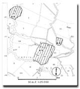
| Location: | 8-093300. Four kilometres north of Carlisle River. | |
Access: | Carlisle-Gellibrand Road. | |
Ownership: | Private land and some Crown Land (Road Reserve). | |
Geomorphology: | A remnant of an erosion terrace 100 m wide occurs north of the Carlisle River. The outer and inner edges of the terrace are clearly defined by low buffers. | |
Significance: | Regional. This is a well preserved terrace remnant in an area where the terrace record is fragmentary. Its correlation with other terrace levels is useful in establishing the erosive and depositional history of streams. | |
© State of Victoria (Agriculture Victoria) 1996 - 2025.

This work, Victorian Resources Online, is licensed under a Creative Commons Attribution 4.0 licence. You are free to re-use the work under that licence, on the condition that you credit the State of Victoria (Agriculture Victoria) as author, indicate if changes were made and comply with the other licence terms.
The licence does not apply to ‘branding’ or some ‘images or photographs’ that may be owned by third parties. We ask you to seek prior approval to use images using the VRO feedback form. Access to higher quality images can also be provided on request.
This page was last updated on 23/03/2020.