
24.4 Cape Otway
This information has been developed from the publications:
|
| Location: | 24-717958. Coastal cliffs and platforms adjacent to Cape Otway lighthouse. |
Access: | Cape Otway Road. |
Ownership: | Australian Government (Lighthouse Reserve). Permission for entry (other than for regular open day visits) must be obtained from the Department of Transport, Navigational Aids Section in Melbourne. |
Geology/Geomorphology: | Bridgewater Formation dune limestone overlies Mesozoic sandstone east and west of Cape Otway. At the Cape, the sandstones are faulted. East of the fault a shallow syncline/anticline sequence is evident in the shore platform. Below the lighthouse is a deep cleft across the shore platform leading to a cave in the sandstones. The cliffs immediately west of the Cape Otway fault are formed in thin bedded siltstone which is unusual in that these rocks generally erode quickly to form embayments. Gill (1977) presents an analysis of the rock indicating it is predominantly quartzose and lacks cleavage. The shore platform east of the Cape extends for approximately one kilometre. It is made up of both Mesozoic rocks and dune limestones. At the present time, the dune limestone platform which has been formed during the Holocene, is being cut back to reveal a platform in the Mesozoic rocks. Apparently, this formed during an earlier (Pleistocene) sea level episode. This sea level must have been approximately equivalent to the present sea level (Eric Bird, pers. comm.). |
Significance: | State. Cape Otway is a major geographical feature of the south coast of Australia. The cliffs clearly display fault and fold structures of the Mesozoic sandstone, and the nature of shore platform development described above appears to be unique on the Victorian coast. |
| References: | Gill, E. D. (1977). "Evolution of the Otway Coast, Victoria, Australia." Proc. Roy. Soc. Vict. 89 (1&2):143-171. |
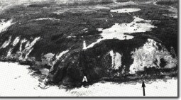 Cape Otway. The Mesozoic rocks are capped by Bridgewater Formation dune limestone. The cave is indicated by A, and the arrow shows the calcarenite platform overlying an earlier platform cut in Mesozoic rock. | 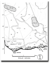 Site 24.2 to 24.6 |
© State of Victoria (Agriculture Victoria) 1996 - .

This work, Victorian Resources Online, is licensed under a Creative Commons Attribution 4.0 licence. You are free to re-use the work under that licence, on the condition that you credit the State of Victoria (Agriculture Victoria) as author, indicate if changes were made and comply with the other licence terms.
The licence does not apply to ‘branding’ or some ‘images or photographs’ that may be owned by third parties. We ask you to seek prior approval to use images using the VRO feedback form. Access to higher quality images can also be provided on request.
This page was last updated on .