
15.3 Gellibrand River confined floodplain at Burrupa
|
This information has been developed from the publications:
|
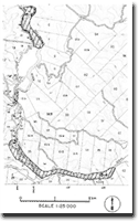
| Location: | 15-959132. One kilometre south of Burrupa. | |
Access: | Gellibrand River Road. | |
Ownership: | Private land. | |
Geomorphology: | The Gellibrand River has developed an entrenched valley at the base of which is a flood plain only 50 m wide. The channel meander amplitude is identical with that of the valley sides and the river has well defined levee banks. | |
Significance: | Regional. This river section illustrates three phases in the development of the lower Gellibrand valley i.e. low sea level stages with rapid valley down cutting; higher sea levels with alluviation and tidal flow transmitted through the channel; renewed down cutting to produce the slight entrenchment of the modern floodplain deposits. | |
© State of Victoria (Agriculture Victoria) 1996 - 2025.

This work, Victorian Resources Online, is licensed under a Creative Commons Attribution 4.0 licence. You are free to re-use the work under that licence, on the condition that you credit the State of Victoria (Agriculture Victoria) as author, indicate if changes were made and comply with the other licence terms.
The licence does not apply to ‘branding’ or some ‘images or photographs’ that may be owned by third parties. We ask you to seek prior approval to use images using the VRO feedback form. Access to higher quality images can also be provided on request.
This page was last updated on 23/03/2020.