
8.8 Carlisle River - Avulsion Channel
|
This information has been developed from the publications:
|
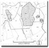
| Location: | 8-093275. Two kilometres south of Carlisle River. | 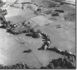 Avulsion channels (arrowed) and isolated hill (A) on the flood plain of the Carlisle River. |
Access: | Moomowroong Road. | |
Ownership: | Private land. | |
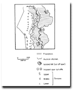
Geomorphology: | The lower Carlisle River valley broadens into a flood plain up to one kilometre wide. An isolated hill of Tertiary sediments occurs on the flood plain and at two locations on the flood plain margin the eroding end of small spurs illustrate stages in the isolating process. Downstream from the small hill, there is a long section of abandoned river course that may indicate a single or sudden shift of the entire river course. This process is known as avulsion. | |
Significance: | Regional. This is one of the longest single abandoned channel sections of the Gellibrand River system and is important in demonstrating that avulsion may be a major process of channel shift in some streams. |
© State of Victoria (Agriculture Victoria) 1996 - 2025.

This work, Victorian Resources Online, is licensed under a Creative Commons Attribution 4.0 licence. You are free to re-use the work under that licence, on the condition that you credit the State of Victoria (Agriculture Victoria) as author, indicate if changes were made and comply with the other licence terms.
The licence does not apply to ‘branding’ or some ‘images or photographs’ that may be owned by third parties. We ask you to seek prior approval to use images using the VRO feedback form. Access to higher quality images can also be provided on request.
This page was last updated on 23/03/2020.