
Mount Porndon
|
This information has been obtained from the report: Eruption Points of the Newer Volcanic Province of Victoria by Neville Rosengren. This report was published in 1994 and was prepared for the National Trust of Australia (Victoria) and the Geological Society of Australia (Victorian Division). The review of eruption points was based on an earlier unpublished manuscript Catalogue of the post-Miocene volcanoes of Victoria compiled by O P Singleton and E B Joyce (Geology Department, University of Melbourne 1970). |
| Location: | 38 19 00S 143 17 00E (external link): 7521-2-4 (POMBORNEIT) 999568. 13 km SE of Camperdown. Shaws Road. | 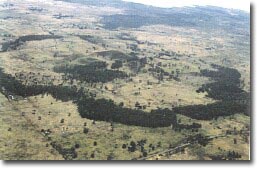 The eruption complex of Mount Porndon. |
| Heytesbury. | ||
| Land Tenure/Use: | Private land. Grazing, fire tower, quarries on lower outer parts of the complex. | |
| Type 9: | Composite volcano of scoria resting on lava disc and tuff. Mount Porndon is the central higher part of a volcanic complex of lava flows, tuff deposits and scoria cones and craters. The site evaluated covers a broad area so as to include the major elements of the volcanic sequence. A number of basalt lava flows extend from Mount Porndon forming rough stony rises, some of which reach Lake Corangamite. The younger of these flows formed an irregular lava disc roughly 3 km in diameter with a distinct and almost continuous perimeter in places forming a rocky wall 10 to 15 m high. The stony rise flows have been dated at 300 000 years. Overlying the lava disc is a thin layer of airfall tuff. The main hills and cones were built from scoria eruptions which succeeded the phreatomagmatic stage after groundwater had been depleted. Small lava flows from some vents beneath the scoria are the last eruptive activity. The central cone of Mount Porndon has a crater 15 m deep and open to the west. Scoria beds with lava bombs including Cr-diopside lherzolite xenoliths are well exposed in small quarries around Mount Porndon. The stony rise lavas retain many original structures including ropy lava surfaces, a gas eruption blister and lava caves. K-Ar analysis on the Porndon lavas gave radiometric ages of 0.300 (+/-) 0.0600 million years and 0.260 (+/-) 0.060 million years. | |
278 m; 105 m. | ||
National: | This site is significant for the varied types of ejecta that occur and for the well-preserved flow topography. The lava disc at the base of the complex is the largest feature of its kind in Australia. It is an important teaching and research site. | |
References: | Skeats, E.W. & James, A.V.G. (1937). Basaltic barriers and other surface features of the Newer Basalts of Western Victoria. Proceedings of the Royal Society of Victoria 49, pp. 245-278. Hills, (1940). The physiography of Victoria (1st edn.). Whitcombe & Tombs. Melbourne. Ollier, C.D. & Joyce, E.B. (1964). Volcanic physiography of the Western Plains of Victoria. Proceedings of the Royal Society of Victoria 77, pp. 357-376. Ollier, C.D. (1967a). Landforms of the Newer Volcanic Province of Victoria. In J.N. Jennings & J.A. Mabbutt (eds), Landform studies from Australia and New Guinea. ANU Press, pp. 315-339. Ollier, C.D. (1967b). Maars: their characteristics, varieties and definition. Bulletin volcanologique 31, pp. 45-73. Ollier, C.D. & Brown, M.C. (1965). The lava caves of Victoria. Bulletin volcanologique 28, pp. 1-15. Henley, K.J. & Webb, A. (1990). Radiometric dating on various granites and Newer Volcanics basalts. Geological Survey of Victoria Unpublished Report 1990/27. Edwards, J. (1991f). Geology of the Pomborneit 1:25 000 map, Port Campbell Embayment, East Otway Basin, Victoria. Geological Survey of Victoria Unpublished Report 1991/10. | |
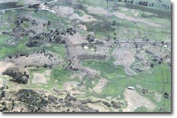 Stony rises on lava flows from Porndon |
© State of Victoria (Agriculture Victoria) 1996 - 2025.

This work, Victorian Resources Online, is licensed under a Creative Commons Attribution 4.0 licence. You are free to re-use the work under that licence, on the condition that you credit the State of Victoria (Agriculture Victoria) as author, indicate if changes were made and comply with the other licence terms.
The licence does not apply to ‘branding’ or some ‘images or photographs’ that may be owned by third parties. We ask you to seek prior approval to use images using the VRO feedback form. Access to higher quality images can also be provided on request.
This page was last updated on 23/03/2020.