
Mount Elephant
|
This information has been obtained from the report: Eruption Points of the Newer Volcanic Province of Victoria by Neville Rosengren. This report was published in 1994 and was prepared for the National Trust of Australia (Victoria) and the Geological Society of Australia (Victorian Division). The review of eruption points was based on an earlier unpublished manuscript Catalogue of the post-Miocene volcanoes of Victoria compiled by O P Singleton and E B Joyce (Geology Department, University of Melbourne 1970). |
| Location: | 37 57 30S 143 12 00E (external link); 7522-3-S (Derrinallum South) 927961. 1 km SW of Derrinallum. Hamilton Highway. |
A 'virtual aerial tour' of Mt Elephant is provided in this video clip. This low quality video clip runs for 1 minute and 23 seconds and is 1.8MB in size, which will take some time to automatically download if you are using a slow internet connection. We also provide a high quality version of the clip, and to view this you need to click on the 'HD' button that appears in the navigation controls for the player. This high quality version of the clip is 4.3MB.
| Click the 'play' button and the video should display directly in your browser if this does not happen you may need to update the 'Adobe Flash Player'. This free software can be downloaded from the Adobe website (external link). |
| Land Tenure/Use: | Private land. Bare, grazing. Large operating quarry complex on lower western slopes and smaller disused (former Railways quarry) nearby. | ||
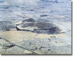
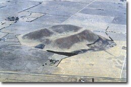
| Type 5: | Scoria cone with breached crater. Mount Elephant is a steep, isolated scoria cone rising almost 200 m above the flat surface of the surrounding lava plain. It is a single eruption point with an irregular rim caused by directed fire fountaining. The rim is breached on the north-eastern side giving an opening to a dry shallow summit crater with minimum enclosure of 20 m. The breach may be the result of collapse or removal of part of the rim during a small lava flow late in the eruption history of the volcano. There are few natural exposures on the mountain but several operating and abandoned pits at the base provide sections into the ejecta. This consists entirely of magmatic material (i.e. without phreatomagmatic) in the form of scoria, blocks and bombs without abundant xenoliths and megacrysts. These occur both in basalt rocks and scoria. Occasional small angular blocks of partially melted granitic bedrock also occur as xenoliths. 393 m; 200 m | ||
| National: | Mt Elephant is one of the most obvious volcanoes in Australia. It has conical form, steep sides, a crater and clear examples of volcanic ejecta are displayed in the quarries. It is the best example of a breached scoria cone in Victoria and possibly in Australia. This is also a major megacryst/xenolith site.
| ||
| References: | Grayson, H.J. & Mahony, D.J. 1910. The geology of the Camperdown and Mount Elephant districts. Geological Survey of Victoria Memoir 9. Ollier, C.D. 1967a. Landforms of the Newer Volcanic Province of Victoria. In J.N. Jennings & J.A. Mabbutt (eds). Landform studies from Australia and New Guinea. ANU Press, pp. 315-339. |
© State of Victoria (Agriculture Victoria) 1996 - 2025.

This work, Victorian Resources Online, is licensed under a Creative Commons Attribution 4.0 licence. You are free to re-use the work under that licence, on the condition that you credit the State of Victoria (Agriculture Victoria) as author, indicate if changes were made and comply with the other licence terms.
The licence does not apply to ‘branding’ or some ‘images or photographs’ that may be owned by third parties. We ask you to seek prior approval to use images using the VRO feedback form. Access to higher quality images can also be provided on request.
This page was last updated on 23/03/2020.