
Lake Bullen Merri
|
This information has been obtained from the report: Eruption Points of the Newer Volcanic Province of Victoria by Neville Rosengren. This report was published in 1994 and was prepared for the National Trust of Australia (Victoria) and the Geological Society of Australia (Victorian Division). The review of eruption points was based on an earlier unpublished manuscript Catalogue of the post-Miocene volcanoes of Victoria compiled by O P Singleton and E B Joyce (Geology Department, University of Melbourne 1970). |
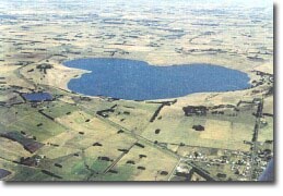
| Location: | 38 15 00S 143 06 00E (external link); 7521-4-3 (Lake Gnotuk) & 7521-3-4 (Cobden) 86755. 2 km SW of Camperdown. Park Road. Hampden. | 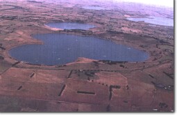 The Maar Crater Lakes of Bullen Merri (foreground) and Gnotuk. |
Land Tenure/Use: | Public land on crater and inner walls. Private land on tuff ring. | |
Type 7: | Tuff ring and maar crater. | |
Lake Bullen Merri lies in a deep maar crater of a clover-leaf outline measuring 3.2 km x 2.8 km. It is surrounded by a tuff ring and a lava flow is exposed discontinuously in the crater wall. Limestone sediments of Tertiary age are also exposed. Rare metapyroxenite xenoliths rich in A1-spinel and garnet are present. The shape of the crater may be due to the coalescing of two or possibly three maar craters. The crater has a steep cone-shaped floor with the base at about 80 m above sea level. The higher points around the rim average 250 m. Present maximum water depth is 67 m with a mean depth of 40 m. Well-defined terraces around the lake indicate much higher previous lake levels. The lake is fresh with salinity average 6o/oo. A number of studies of the sediment and fossil material of the lake floor have reconstructed the water level and salinity history of this and nearby maars. | ||
280+ m; 100 m (above lake surface); 200 m (to lake floor). | ||
International: | This is a large and complex multiple maar and it is the deepest such feature in the Newer Volcanics of Victoria. It forms one of the major sites for the study of Late Quaternary climatic fluctuations, preserved in the sediments, pollens and diatom communities recovered from lake floor deposits. It is also an important xenolith site. | 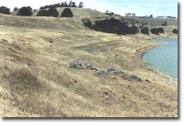 Erosion benches marking former higher lake level shorelines of Lake Bullen Merri. |
References: | Grayson, H.J. & Mahony, D.J. 1910. The geology of the Camperdown and Mount Elephant Districts. Geological Survey of Victoria Memoir 9. Gill, E.D. 1953. Geological evidence in western Victoria relative to the antiquity of the Australian Aborigines. Memoir of the National Museum of Victoria 18, pp. 25-92. Ollier, C.D. 1967a. Landforms of the Newer Volcanic Province in Victoria. In J.N. Jennings & J.A. Mabbutt (eds), Landform studies from Australia and New Guinea. ANU Press, pp. 315-339. Ollier, C.D. 1967b. Maars: their characteristics, varieties and definition. Bulletin volcanologique 31, pp. 45-73. Hills, E.S. 1975. The physiography of Victoria (5th edn). Whitcombe & Tombs, Melbourne. DeDeckker, P. 1982. Holocene ostracods, other invertebrates and fish remains from cores of four maar lakes in south-eastern Australia. Proceedings of the Royal Society of Victoria 94, pp. 183-220. Price, R.C., Gray C.M., Nicholls, I.A. & Day, A. 1988. Cainozoic volcanic rocks. In J.G. Douglas and J.A. Ferguson (eds) Geology of Victoria. Geological Society of Australia, Victorian Division, Melbourne, pp. 439-451. | |
 Lake Bullen Merri |
© State of Victoria (Agriculture Victoria) 1996 - 2025.

This work, Victorian Resources Online, is licensed under a Creative Commons Attribution 4.0 licence. You are free to re-use the work under that licence, on the condition that you credit the State of Victoria (Agriculture Victoria) as author, indicate if changes were made and comply with the other licence terms.
The licence does not apply to ‘branding’ or some ‘images or photographs’ that may be owned by third parties. We ask you to seek prior approval to use images using the VRO feedback form. Access to higher quality images can also be provided on request.
This page was last updated on 23/03/2020.