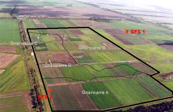
SFS1
Location: Gnarwarre
Australian Soil Classification: Vertic (& Sodic), Self-Mulching, Grey VERTOSOL
General Landscape Description: Plain.
Site Description: Gnarwarre Farming Systems trial site raised bed cropping.
Geology: Quaternary - Newer Volcanics.
Map Unit: Gnarwarre B soil (Adcock, 1998).

SFS1 Landscape. Also shows the Map Units within the Gnarwarre SFS trial site.
Soil Profile Morphology:
| Surface Soil |  SFS1 Profile. | ||
| Ap | 0-20 cm | Very dark greyish brown (10YR3/2); light clay (fine sandy); strong fine polyhedral structure; pH 5.6; abrupt change to: | |
| Subsoil | |||
| B21g | 20-50/70 cm | Dark grey (10YR4/1) with many yellowish brown (10YR5/8) mottles; black (10YR2/1) infills in cracks; heavy clay; very coarse angular blocky and polyhedral structure; pH 7.5; gradual and irregular change to: | |
| B22 | 50/70-100/110 cm | Dark grey (2.5Y4/1); medium clay; occasional patches of soft calcium carbonate; slightly calcareous; very coarse to coarse lenticular structure; slickensides present; pH 8.8; clear and wavy change to: | |
| B23k | 100/110+ cm | Dark greyish brown (2.5Y4/2); light clay to light medium clay; calcium carbonate present; basalt floaters present at 120 cm; pH 9.2. | |
Key Profile Features:
- Cracks to 90 cm depth.
Soil Profile Characteristics:
pH | Salinity Rating | |||
Surface (A1 horizon) | Moderately Acid | Low | Non-Sodic | None1 |
Subsoil (B21 horizon) | Slightly Alkaline | Low | Sodic | None1 |
Deeper Subsoil (at 1 m) | Very Strongly Alkaline | Medium | Strongly Sodic | Moderate - Strong |

| The pH in the surface is moderately acid. The pH in the subsoil is slightly alkaline becoming very strongly alkaline with depth. | The salinity rating is low in both the surface and upper subsoil. The salinity rating increases to medium in the deeper subsoil. | The surface is non sodic. The subsoil is sodic becoming strongly sodic with depth. | The clay content is moderate throughout the profile. |
Horizon | Horizon Depth (cm) | pH (water) | pH (CaCl2) | EC dS/m | NaCl % | Exchangeable Cations | |||
Ca | Mg | K | Na | ||||||
meq/100g | |||||||||
AP | 0-20 | 5.6 | 4.6 | 0.15 | 5.3 | 6.4 | 0.73 | 1 | |
B21g | 20-50/70 | 7.5 | 6.2 | 0.14 | 5.5 | 10 | 0.7 | 2.5 | |
B22 | 50/70-100/110 | 8.8 | 7.7 | 0.3 | 0.04 | 5.6 | 12 | 0.5 | 4.3 |
B23K | 100/110+ | 9.2 | 8.5 | 0.66 | 0.07 | 7.1 | 15 | 0.6 | 5.9 |
Horizon | Horizon Depth (cm) | Exchangeable Aluminium mg/kg | Exchangeable Acidity meq/100g | Oxidisable Organic Carbon % | Total Nitrogen % | Field Capacity pF2.5 | Wilting Point pF4.2 | Coarse Sand (0.2-2.0 mm) | Fine Sand (0.02-0.2 mm) | Silt (0.002-0.02 mm) | Clay (<0.002 mm) |
AP | 0-20 | 12 | 11 | 2.3 | 0.21 | 29.4 | 14.3 | 19 | 36 | 13 | 28 |
B21g | 20-50/70 | 34.1 | 16.2 | 15 | 36 | 13 | 35 | ||||
B22 | 50/70-100/110 | 35.3 | 16.4 | 16 | 36 | 10 | 38 | ||||
B23K | 100/110+ | 44.6 | 20.5 | 13 | 27 | 13 | 43 |
Management Considerations:
Whole Profile
- Plant available water capacity (PAWC) is considered to be low (estimated at 94 mm) in the upper 100 cm of this soil profile.
Profile Described By: Richard MacEwan (May 1999).
Reference:
Adcock D 1998. Gnarwarre Soil Survey. Centre for Environmental Management, University of Ballarat. unpublished.


