
SW73
Location: Tulloh
Australian Soil Classification: Bleached-Mottled, Mesotrophic, Brown CHROMOSOL
General Landscape Description: Undulating low hills.
Site Description: Waxing upper slope (10%), eastern aspect.
Geology: Ambiguous: Either Dilwyn (Colac 1:250 000) or Eastern View Formation (Colac 1:50 000).
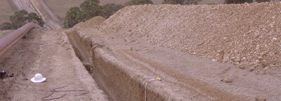 SW73 Landscape |
Soil Profile Morphology:
Surface Soil
| A1 | 0-20* cm | Dark brown (10YR3/3 moist), fine sandy loam; weakly pedal; weak consistence dry; pH 5.4: | 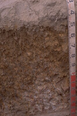 SW73 Profile. Note: Surface (A1) horizon has been stripped from the soil profile |
| A2 | 20*-40 cm | Dark greyish brown (10YR4/2 moist), pale brown (10YR6/3 dry); conspicuously bleached; sandy loam; apedal, massive; very firm consistence dry; (minor <5%), fine (5-15 mm), irregular rounded ferruginised sandstone gravel; pH 5.6; abrupt to clear and wavy change to: | |
| Subsoil | |||
| B21t | 40-70 cm | Dark yellowish brown (10YR4/5 dry); with prominent (5-15 mm), red (10R4/8 moist) to dark red (2.5YR4/8 moist) to yellowish brown (10YR6/8 moist) mottles in ped interiors, reddest in ped centres; medium clay; coarse prismatic structure; pH 5.8; strong consistence (dry); gradual change to: | |
| B22t | 70/80-100/110 cm | Dark yellowish brown (10YR4/5 moist and dry) with prominent (5-15 mm), red (10R4/8 moist) to dark red (2.5YR4/8 moist) to yellowish brown (10YR6/8 moist) mottles in ped interiors (reddest away from ped face); medium clay; white (2.5Y8/1) clay adjacent to cutans; pH 6; gradual change to: | |
| B/C | 100/110 cm+ | Weak red to dusky red (10R5/3-3/2); ferruginised sandstone with yellowish and white edges; clay infill and weathering in joints; pH 6.0. |
* Depth is a guess due to horizon not being present.
Key Profile Features:
- Strong texture contrast between surface (A) horizons and subsoil (B21) horizon.
Soil Profile Characteristics:
pH | Salinity Rating | |||
Surface (A1 horizon) | Strongly Acid | Low - Moderate | Non-Sodic | None |
Subsoil (B21 horizon) | Moderately Acid | Very Low | Non-Sodic | None |
Deeper subsoil (at 100+ cm) | Moderately Acid | Very Low | Non-Sodic | None |
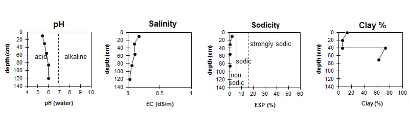
| The surface soil is strongly acid. The subsoil is moderately acid. | Salinity rating is low to moderate in the surface becoming very low in the subsoil. |
| The clay content increases markedly at the A/B boundary. |
Horizon | Sample Depth (cm) | pH (water) | pH (CaCl2) | EC 1:5 | Nitrogen % | Organic Carbon % | Exchangeable Cations | |||
Ca | Mg | K | Na | |||||||
meq/100g | ||||||||||
A1 | 0-20* | 5.4 | 4.8 | 0.17 | 0.35 | 4.3 | 5.2 | 1.1 | 0.49 | 0.32 |
A2 | 20*-40 | 5.6 | 4.9 | 0.1 | 0.62 | 0.91 | 0.07 | 0.1 | ||
B21 | 40-70 | 5.8 | 5.2 | 0.11 | 1.9 | 7.4 | 0.1 | 0.53 | ||
B22 | 70-105 | 6 | 5.2 | 0.06 | 1.5 | 6.4 | 0.07 | 0.4 | ||
BC | 105+ | 6 | 5.2 | <0.05 | ||||||
Horizon | Sample Depth (cm) | Exchangeable Aluminium mg/kg | Exchangeable Acidity meq/100g | Field Capacity pF2.5 | Wilting Point pF4.2 | Coarse Sand (0.2- 2.0 mm) | Fine Sand (0.02- 0.2 mm) | Silt (0.002- 0.02 mm) | Clay (<0.002 mm) |
A1 | 0-20* | 17 | 15 | 26.5 | 10.2 | 24 | 38 | 12 | 13 |
A2 | 20*-40 | <10 | 4.8 | 14.6 | 4.2 | 25 | 46 | 22 | 6 |
B21 | 40-70 | <10 | 9.4 | 42.4 | 27.6 | 9 | 11 | 8 | 74 |
B22 | 70-105 | <10 | 7.9 | 36 | 23.6 | 16 | 12 | 7 | 63 |
BC | 105+ |
Management Considerations:
Notes
- Similar pattern on both sides of unnamed creek. Soils increasingly vertic downslope, gleying increases, A2 thickens. Colluvial derived from and lying on Tad or Tae2. Becoming quite pallid in places below colluvial mass. Fragments are angular, occasional weakly rounded and up to 200 mm diameter at largest, generally ~100 mm.
Profile Described By: Richard McEwan (April 1999).
© State of Victoria (Agriculture Victoria) 1996 - 2025.

This work, Victorian Resources Online, is licensed under a Creative Commons Attribution 4.0 licence. You are free to re-use the work under that licence, on the condition that you credit the State of Victoria (Agriculture Victoria) as author, indicate if changes were made and comply with the other licence terms.
The licence does not apply to ‘branding’ or some ‘images or photographs’ that may be owned by third parties. We ask you to seek prior approval to use images using the VRO feedback form. Access to higher quality images can also be provided on request.
This page was last updated on 23/03/2020.