SW72
Location: Tulloh
Australian Soil Classification: Bleached-Vertic, Magnesic, Brown CHROMOSOL
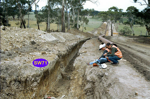
General Landscape Description: Undulating low hills.
Site Description: Mid slope, simple slope.
Geology: Otway Group (volcanogenic sandstone).

SW72 Landscape is behind the camera.
Soil Profile Morphology:
Surface Soil
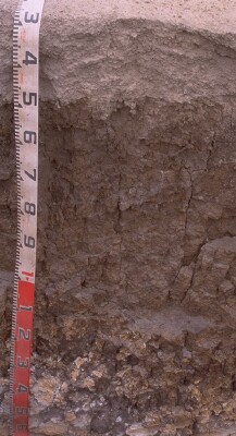
| A1 | 0-20 cm | Very dark gray (10YR3/1 moist), gray (10YR5/1 dry); fine sandy clay loam, moderately pedal, crumb; weak to firm consistence dry; pH 5.3: |  SW72 Profile. Note: Surface (A1) horizon has been stripped from the soil profile |
| A2 | 20-45/50 cm | Light brownish gray (10YR6/2 moist), conspicuously bleached (10YR7/1 dry); fine sandy loam; apedal; hardsetting; very firm consistence dry; fine (<10 mm) ferruginous gravel (some magnetic), up to 50% or more, in lower 100 mm; pH 6.0; sharp and slightly wavy change to: | |
| Subsoil | |||
| B21tss | 45/50-100/120 cm | Dark brown (10YR3/3 moist, dry); few (<10%), fine red and fine yellow mottles, red mottles becoming prominent [up to 30%] and larger (~10 mm) with depth, yellow fringes; medium clay to medium heavy clay; coarse prismatic and coarse lenticular structure, [becoming coarser with depth]; larger (>300 mm) slickensides underlying several peds; pH 6; clear/gradual change to: | |
| B22t | 100/120-140/150 cm | Mottled yellowish red (5YR5/8 moist) or brownish yellow (10YR6/8 moist) and white peds with black (5Y2.5/1) clay coatings on ped faces; medium heavy clay; medium prismatic to angular blocky (30-50 mm) peds with sandier matrix in interior; strong consistence dry; pH 5.4; gradual change to: | |
| C/B | 140/150 cm+ | Red and white mottled, fine weathered sandstone with black clay and organic coatings in cracks. |
Key Profile Features:
- Conspicuously bleached subsurface (A2) horizon.
- Strong texture contrast between surface (A) horizons and subsoil (B21) horizon.
- Slickensides in subsoil.
Soil Profile Characteristics:
pH | Salinity Rating | |||
Surface (A1 horizon) | Strongly Acid | Low | Non-Sodic | None |
Subsoil (B21 horizon) | Moderately Acid | Very Low | Non-Sodic | None |
Deeper subsoil (at 150+ cm) | Strongly Acid | Very Low | Non-Sodic | None |

| The surface soil is strongly acid. The deeper subsoil is moderately acid. | Salinity rating is low in the surface becoming very low in the subsoil. |
| Exchangeable Aluminium levels are high in the deeper subsoil. | The clay content increases markedly at the A/B boundary. |
Horizon | Sample Depth (cm) | pH (water) | pH (CaCl2) | EC 1:5 | Nitrogen % | Organic Carbon % | Exchangeable Cations | |||
Ca | Mg | K | Na | |||||||
meq/100g | ||||||||||
A1 | 0-10 | 5.3 | 4.5 | 0.1 | 0.34 | 4.4 | 2.8 | 1.9 | 0.28 | 0.32 |
A2 | 30-45 | 6 | 5 | <0.05 | 0.72 | 1.5 | <0.05 | 0.19 | ||
B21 | 60-80 | 6 | 4.9 | 0.11 | 1.4 | 12 | 0.18 | 1.1 | ||
B22 | 120-140 | 5.4 | 4.4 | 0.1 | 0.29 | 7.8 | 0.12 | 0.93 | ||
Horizon | Sample Depth (cm) | Exchangeable Aluminium mg/kg | Exchangeable Acidity meq/100g | Field Capacity pF2.5 | Wilting Point pF4.2 | Coarse Sand (0.2- 2.0 mm) | Fine Sand (0.02- 0.2 mm) | Silt (0.002- 0.02 mm) | Clay (<0.002 mm) |
A1 | 0-10 | 57 | 16 | 30.4 | 11.5 | 12 | 38 | 28 | 14 |
A2 | 30-45 | <10 | 6.2 | 17.9 | 7 | 17 | 46 | 16 | 15 |
B21 | 60-80 | 22 | 13 | 41.1 | 26.3 | 3 | 12 | 9 | 72 |
B22 | 120-140 | 190 | 12 | 34.3 | 20.4 | 4 | 18 | 15 | 62 |
Management Considerations:
Subsoil (B) Horizons
- This subsoil has a very low ratio of exchangeable calcium relative to exchangeable magnesium (i.e. magnesic).
- The strongly acid deeper subsoil has high levels of exchangeable calcium.
Profile Described By: Richard McEwan (April 1999).


