Yinnar (Yn)
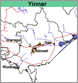
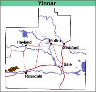
| Geology Late Pleistocene alluvial sediments (most likely outwash from nearby hills). Landform Stagnant alluvial plain. This is an old flood plain with now defunct, poorly defined stream channels, levees, flood plains and back swamps. |  |  |
Variable - species most likely are swamp gum, narrow leaf peppermint, manna gum with red gum (particularly west of Traralgon). Swamp Paperbark and various acacias probably formed the tall shrub understorey.
Previous Maps and Reports
Most of the area covered by the present mapping unit was mapped as the Yinnar Land System by Aldrick et al. (1992).
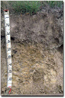
| Soils The soils may be classified into two broad groups: firstly the soils on the slightly higher ground and broad plains, and secondly, the soils in the slightly depressed parts of the plain and depressions. The soils of the first group are the major component of the Yinnar map unit. They have a depth to subsoil clay which is generally quite deep, typically 40 cm to 60 cm. The surface soils are generally fine sandy loams to silty clay loams which are dark greyish brown or dark brownish grey, often with a sporadically bleached sub-surface. There is a clear to abrupt change to the mottled light to medium clay subsoil with brown and brownish yellow colours dominating. Pale coloured medium to heavy clays continue to at least 1 m depth. These soils are generally classified as Brown and Grey Chromosols using the Australian Soil Classification. The soils in the slightly depressed parts of the plain and depressions are generally darker and greyer in colour. They are also heavier in texture with surface soils frequently being light clays (these soils are classified as Vertosols). Soil Pit Site GP16 is an example of a Black Vertosol in this mapping unit. |  Texture contrast soil in the Yinnar mapping unit. |
Chemical and Physical Analysis
No analyses of this soil were carried out during the present survey. The limited data available suggests that the pH of the surface soils is generally less than 6.0 but normally greater than 5.0 and the soil profile remains acidic with depth. It would appear that although they may be sodic at depth, the immediate subsoil is non-sodic.
Land Use
All of this map unit is cleared and the soils used for intensive grazing, usually dairy and beef cattle.


