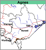
Agnes (Ag)
 | Geology Late Pleistocene to Recent alluvium and colluvium derived from the Gippsland uplands. Landform Gently undulating plain. |
Soils
The surface soils are dark grey to dark greyish brown very fine (or silty) sandy clay loams to heavy clay loams overlying, at about 30 cm, paler light brownish grey sub-surface soils of similar texture.
Mottled light to medium clays appear at about 60 to 80 cm, with light brownish grey and yellowish brown being the usual colours. It is likely that these soils would be classified as grey Dermosols.
Land Use
The soils of this map unit are mostly cleared and used for grazing. Small areas of Swamp Paperbark (Melaleuca ericifolia) remain.


