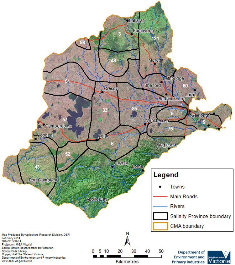
Salinity Provinces in the Corangamite Catchment Management Region
The Corangamite catchment lies between the Otway Coast, Ballarat and Geelong in south-west central Victoria. Steeply dissected terrain of the Otway Ranges gives way to low hills and volcanic plains of the Camperdown to Geelong middle area before rising again to the moderate elevations of the northern uplands around Ballarat.
The region experiences a temperate climate with dominant westerly winds, variable cloud, moderate precipitation and cool temperatures. Winter rainfall predominates, while summers are warm and dry. Streams are generally perennial, though with much reduced flows in summer. Rainfall varies greatly across the Region – highest along the Otway Ridge and the northern uplands. The central valley, comprising the Basalt Plain, is in a rain shadow, and experiences much lower rainfall.
Livestock grazing is the dominant land-use in in the south of the Region and dryland agriculture tends to occupy the central valley and northern slopes. There is little irrigation compared with northern Victorian regions. There is a minimal area of nature conservation in the Moorabool and Barwon River catchment areas, but a high level of nature conservation and forest in the Otway Coast Basin. European settlement led to massive changes in land use, including the removal of native grasslands for crops and introduced pastures, as well as woody vegetation removal for agriculture, construction timber, firewood and gold mining requirements.
Salinity has been a natural feature of the Corangamite region for at least 20 000 years. The geologically young age of the volcanic landscape, poor surface drainage and terminal lakes such as Lake Corangamite and Lake Murdeduke testify to the presence of this primary salinity. Approximately 16,700 hectares1 of salinity has been recorded in the Corangamite region (not including large lakes or coastal estuarine areas). About half is primary salinity, with secondary salinity (salinity associated with land clearing and land-use change) a significant threat to land productivity in the Lakes/Plains & Northern Foothills sub-Region.
Over 1200 individually mapped units1 of soil salinity have been recorded in the catchment. These have been grouped into 15 Salinity Provinces (including 12 High priority Provinces) based on geographic and biophysical similarities and to aid in monitoring and reporting salinity risk.
The Corangamite CMA has an extensive range of online materials (maps and documents etc.) which outline the biophysical assets of the catchment, as well as their major risks (including soil and water salinity). This material also outlines the programs and projects currently being completed by the CMA to protect and enhance these assets. An example of this is the online data portal called the Corangamite CMA ‘Knowledge Base’, the link to which can be found at the base of this page.
Provinces displayed in this map are clickable or use the table of links provided

Province Name | No. | Area of Province (ha) | Recorded Soil Salinity Area 1 (ha) | Soil Salinity Area (% of SP) |
| Ballarat Hills | 3 | 68,070 | 348 | 0.51% |
| Barrabool Hills | 5 | 20,680 | 1 | 0.01% |
| Barwon Downs | 6 | 58,950 | 1,279 | 2.17% |
| Connewarre Lakes | 19 | 27,850 | 1,867 | 6.70% |
| Eurack | 33 | 76,200 | 6,086 | 7.99% |
| Heytesbury | 43 | 79,300 | 516 | 0.65% |
| Illabarook | 48 | 40,610 | 612 | 1.51% |
| Irrewillipe | 52 | 31,470 | 37 | 0.12% |
| Lake Corangamite | 57 | 123,420 | 1,223 | 0.99% |
| Lara | 60 | 44,260 | 233 | 0.53% |
| Lismore | 64 | 71,680 | 2,032 | 2.83% |
| Modewarre | 75 | 34,590 | 103 | 0.30% |
| Murdeduke | 85 | 81,260 | 1,164 | 1.43% |
| Pittong | 98 | 6,810 | 218 | 3.21% |
| Upper Moorabool | 121 | 114,890 | 206 | 0.18% |
1 Please Note: The ‘Recorded Soil Salinity Area (ha)’ and ‘number of individually mapped units’ indicated in the text and/or table, comprises the ‘total geographic area’ or ‘number of sites’ that have been mapped as having, or showing symptoms of dryland soil salinity by DEDJTR (or its predecessors) at some time (past or present). As dryland salinity occurrence in the Victorian landscape exhibits many different levels of severity and can change due to climate, landuse and vegetation cover etc., previously mapped areas may no longer be showing symptoms of salinity and/or new areas may have occurred since the mapping was completed. In addition, as not all parts of the state have been mapped, or mapped in the same way, the mapping may not have captured some occurrences.
Recorded soil salinity mapping used for these pages does not cover irrigation regions. Instead, depth to watertable and watertable salinity mapping has been used to convey the threat of high watertables on soil waterlogging and/or soil salinisation.
For more information about salinity in your location, please contact the DEDJTR, DELWP, your Catchment Management Authority (CMA) or your rural water provider.
Links to further reading and material related to the Corangamite CMR
Corangamite Catchment Management Authority region on VRO
Corangamite Catchment Management Authority
Corangamite CMA ‘Regional Catchment Strategy ’ (RCS)
Corangamite CMA ‘Waterway Strategy’
Corangamite CMA ‘Knowledge Base’ (Interactive Maps)
Information about bores and groundwater resources in the Corangamite CMA can be found on the Visualising Victoria’s Groundwater (VVG) website


